

The Demi Ardèche-Cévennes Divide
A cycling route starting in Montélimar, Auvergne-Rhône-Alpes, France.
Overview
About this route
Laboule > Le beaume au coeur
- -:--
- Duration
- 218.4 km
- Distance
- 5,962 m
- Ascent
- 5,905 m
- Descent
- ---
- Avg. speed
- ---
- Max. altitude

Route quality
Waytypes & surfaces along the route
Waytypes
Track
77.1 km
(35 %)
Busy road
42.2 km
(19 %)
Surfaces
Paved
38.3 km
(18 %)
Unpaved
52.6 km
(24 %)
Gravel
38.2 km
(17 %)
Asphalt
30.4 km
(14 %)
Route highlights
Points of interest along the route
Accommodation after 65.3 km
Camping La Beaume au coeur
Continue with Bikemap
Use, edit, or download this cycling route
You would like to ride The Demi Ardèche-Cévennes Divide or customize it for your own trip? Here is what you can do with this Bikemap route:
Free features
- Save this route as favorite or in collections
- Copy & plan your own version of this route
- Split it into stages to create a multi-day tour
- Sync your route with Garmin or Wahoo
Premium features
Free trial for 3 days, or one-time payment. More about Bikemap Premium.
- Navigate this route on iOS & Android
- Export a GPX / KML file of this route
- Create your custom printout (try it for free)
- Download this route for offline navigation
Discover more Premium features.
Get Bikemap PremiumFrom our community
Other popular routes starting in Montélimar
 Montélimar to Fournès
- Distance
- 87.4 km
- Ascent
- 654 m
- Descent
- 674 m
- Location
- Montélimar, Auvergne-Rhône-Alpes, France
 2016 Ride Day 98 - Montélimar to Vesc
- Distance
- 42.6 km
- Ascent
- 613 m
- Descent
- 101 m
- Location
- Montélimar, Auvergne-Rhône-Alpes, France
 C'est beau le Niger (provençal) à vélo 2016
- Distance
- 365.8 km
- Ascent
- 2,835 m
- Descent
- 2,886 m
- Location
- Montélimar, Auvergne-Rhône-Alpes, France
 6- Montélimar - Roquemaure
- Distance
- 76.6 km
- Ascent
- 12 m
- Descent
- 64 m
- Location
- Montélimar, Auvergne-Rhône-Alpes, France
 Montelimar - Mont Ventoux
- Distance
- 153.9 km
- Ascent
- 1,895 m
- Descent
- 83 m
- Location
- Montélimar, Auvergne-Rhône-Alpes, France
 13. Tag Saint Julien du Gua - Saint Nazaire en Royans
- Distance
- 103.8 km
- Ascent
- 219 m
- Descent
- 132 m
- Location
- Montélimar, Auvergne-Rhône-Alpes, France
 Aleyrac
- Distance
- 63.2 km
- Ascent
- 791 m
- Descent
- 791 m
- Location
- Montélimar, Auvergne-Rhône-Alpes, France
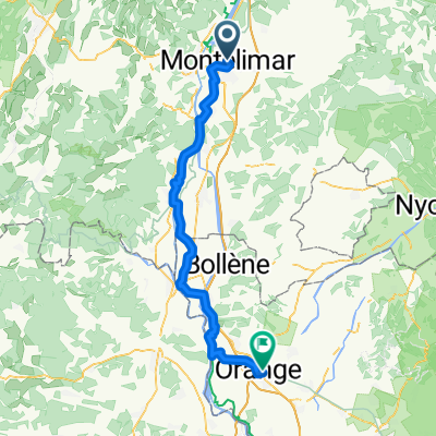 V-4. Montelimar - Orange
- Distance
- 72.1 km
- Ascent
- 187 m
- Descent
- 225 m
- Location
- Montélimar, Auvergne-Rhône-Alpes, France
Open it in the app