

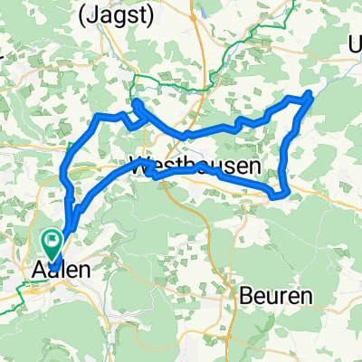
Remstalradroute
A cycling route starting in Aalen, Baden-Wurttemberg, Germany.
Overview
About this route
<p>In mighty meanders, the Rems winds through the nature reserve Unteres Remstal before flowing into the Neckar north of Stuttgart. In Remseck, your journey begins through a unique combination of history, picturesque landscape, and friendly way of life.
(Tour description at: thod_er@gmx.de)</p>
Translated, show original (German)- -:--
- Duration
- 72.6 km
- Distance
- 3,847 m
- Ascent
- 4,276 m
- Descent
- ---
- Avg. speed
- 498 m
- Max. altitude
Route quality
Waytypes & surfaces along the route
Waytypes
Quiet road
29 km
(40 %)
Track
23.2 km
(32 %)
Surfaces
Paved
61.7 km
(85 %)
Unpaved
5.8 km
(8 %)
Asphalt
58.8 km
(81 %)
Gravel
5.1 km
(7 %)
Continue with Bikemap
Use, edit, or download this cycling route
You would like to ride Remstalradroute or customize it for your own trip? Here is what you can do with this Bikemap route:
Free features
- Save this route as favorite or in collections
- Copy & plan your own version of this route
- Sync your route with Garmin or Wahoo
Premium features
Free trial for 3 days, or one-time payment. More about Bikemap Premium.
- Navigate this route on iOS & Android
- Export a GPX / KML file of this route
- Create your custom printout (try it for free)
- Download this route for offline navigation
Discover more Premium features.
Get Bikemap PremiumFrom our community
Other popular routes starting in Aalen
 Aalen Bucherstausee Lauchheim Aalen
- Distance
- 50 km
- Ascent
- 334 m
- Descent
- 334 m
- Location
- Aalen, Baden-Wurttemberg, Germany
 Welland
- Distance
- 32.8 km
- Ascent
- 203 m
- Descent
- 193 m
- Location
- Aalen, Baden-Wurttemberg, Germany
 Härtsfeldrunde
- Distance
- 62.3 km
- Ascent
- 596 m
- Descent
- 533 m
- Location
- Aalen, Baden-Wurttemberg, Germany
 Kocher-Jagst-Radweg
- Distance
- 338.1 km
- Ascent
- 4,732 m
- Descent
- 4,733 m
- Location
- Aalen, Baden-Wurttemberg, Germany
 Runde um Neuler
- Distance
- 45.8 km
- Ascent
- 792 m
- Descent
- 770 m
- Location
- Aalen, Baden-Wurttemberg, Germany
 2013-07-21 Andres Runde mit Kirschen
- Distance
- 58 km
- Ascent
- 435 m
- Descent
- 437 m
- Location
- Aalen, Baden-Wurttemberg, Germany
 Kochertal Aalen - Schwäbisch Hall - Bad Friedrichsau Tag 1
- Distance
- 73.3 km
- Ascent
- 205 m
- Descent
- 369 m
- Location
- Aalen, Baden-Wurttemberg, Germany
 Kocher-Jagst ab/bis Aalen
- Distance
- 333.4 km
- Ascent
- 682 m
- Descent
- 681 m
- Location
- Aalen, Baden-Wurttemberg, Germany
Open it in the app