

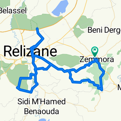
شارع نسلي الشارف, زمورة to شارع نسلي الشارف, زمورة
A cycling route starting in Zemoura, Relizane Province, Algeria.
Overview
About this route
- 1 h 33 min
- Duration
- 27.3 km
- Distance
- 175 m
- Ascent
- 146 m
- Descent
- 17.6 km/h
- Avg. speed
- ---
- Max. altitude

Route quality
Waytypes & surfaces along the route
Waytypes
Quiet road
3.8 km
(14 %)
Undefined
23.5 km
(86 %)
Surfaces
Paved
23.5 km
(86 %)
Asphalt
23.5 km
(86 %)
Undefined
3.8 km
(14 %)
Continue with Bikemap
Use, edit, or download this cycling route
You would like to ride شارع نسلي الشارف, زمورة to شارع نسلي الشارف, زمورة or customize it for your own trip? Here is what you can do with this Bikemap route:
Free features
- Save this route as favorite or in collections
- Copy & plan your own version of this route
- Sync your route with Garmin or Wahoo
Premium features
Free trial for 3 days, or one-time payment. More about Bikemap Premium.
- Navigate this route on iOS & Android
- Export a GPX / KML file of this route
- Create your custom printout (try it for free)
- Download this route for offline navigation
Discover more Premium features.
Get Bikemap PremiumFrom our community
Other popular routes starting in Zemoura
 De N4, Oued el Djemaa à Unnamed Road, Oued El Djemaa
- Distance
- 2.2 km
- Ascent
- 99 m
- Descent
- 79 m
- Location
- Zemoura, Relizane Province, Algeria
 شارع نسلي الشارف, زمورة to شارع نسلي الشارف, زمورة
- Distance
- 27.3 km
- Ascent
- 175 m
- Descent
- 146 m
- Location
- Zemoura, Relizane Province, Algeria
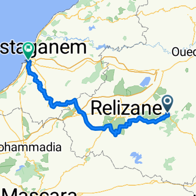 Mostaganem
- Distance
- 111.3 km
- Ascent
- 1,018 m
- Descent
- 1,214 m
- Location
- Zemoura, Relizane Province, Algeria
 zemmora
- Distance
- 105.7 km
- Ascent
- 1,053 m
- Descent
- 1,054 m
- Location
- Zemoura, Relizane Province, Algeria
Open it in the app