
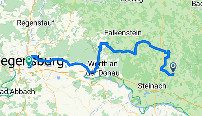
Mitterfels-Brennberg-Regensburg
A cycling route starting in Haselbach, Bavaria, Germany.
Overview
About this route
Eine Rückweg-Variante über den Gallner nach Brennberg. Da kann man gut einkehren und außerdem das geniale Hölltal runter heimrollen. Die letzten Meter dann auf dem Donauradweg.
- -:--
- Duration
- 80.1 km
- Distance
- 854 m
- Ascent
- 912 m
- Descent
- ---
- Avg. speed
- ---
- Max. altitude
Continue with Bikemap
Use, edit, or download this cycling route
You would like to ride Mitterfels-Brennberg-Regensburg or customize it for your own trip? Here is what you can do with this Bikemap route:
Free features
- Save this route as favorite or in collections
- Copy & plan your own version of this route
- Split it into stages to create a multi-day tour
- Sync your route with Garmin or Wahoo
Premium features
Free trial for 3 days, or one-time payment. More about Bikemap Premium.
- Navigate this route on iOS & Android
- Export a GPX / KML file of this route
- Create your custom printout (try it for free)
- Download this route for offline navigation
Discover more Premium features.
Get Bikemap PremiumFrom our community
Other popular routes starting in Haselbach
 Haselbach -Cham-Roding-Falkenstein-Haselbach
- Distance
- 111.3 km
- Ascent
- 784 m
- Descent
- 775 m
- Location
- Haselbach, Bavaria, Germany
 Johann-Baier-Straße, Haselbach nach Hubrichstraße 4, Mitterfels
- Distance
- 6.8 km
- Ascent
- 62 m
- Descent
- 46 m
- Location
- Haselbach, Bavaria, Germany
 Bad Kötzting
- Distance
- 29.7 km
- Ascent
- 199 m
- Descent
- 188 m
- Location
- Haselbach, Bavaria, Germany
 Regen
Regen- Distance
- 69.8 km
- Ascent
- 669 m
- Descent
- 538 m
- Location
- Haselbach, Bavaria, Germany
 Mitterfels-Brennberg-Regensburg
- Distance
- 80.1 km
- Ascent
- 854 m
- Descent
- 912 m
- Location
- Haselbach, Bavaria, Germany
 drachensee
- Distance
- 50.8 km
- Ascent
- 188 m
- Descent
- 222 m
- Location
- Haselbach, Bavaria, Germany
 haselbach-patersdorf-Deggendorf
- Distance
- 119.6 km
- Ascent
- 638 m
- Descent
- 634 m
- Location
- Haselbach, Bavaria, Germany
 Tiefenbachstraße 13, Haselbach nach Am Sportplatz, Wiesenfelden
- Distance
- 17.2 km
- Ascent
- 399 m
- Descent
- 290 m
- Location
- Haselbach, Bavaria, Germany
Open it in the app