

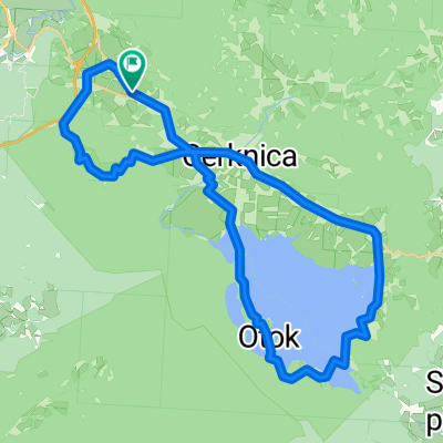
Rakov Škocjan Unška Koliševka Cerkniško
A cycling route starting in Rakek, Cerknica, Slovenia.
Overview
About this route
- -:--
- Duration
- 30.5 km
- Distance
- 358 m
- Ascent
- 373 m
- Descent
- ---
- Avg. speed
- ---
- Max. altitude

Route quality
Waytypes & surfaces along the route
Waytypes
Quiet road
18 km
(59 %)
Road
7 km
(23 %)
Surfaces
Paved
3.7 km
(12 %)
Unpaved
21.4 km
(70 %)
Gravel
17.4 km
(57 %)
Asphalt
3.7 km
(12 %)
Route highlights
Points of interest along the route
Photo after 2 km
Črna jama Black cave
Point of interest after 2 km
Pivka jama - Pivka cave
Point of interest after 2 km
Lovska koča Črna Jama
Point of interest after 7.6 km
Tkalca jama ( ponor ) The Tkalca cave - (sinking hole)
Point of interest after 9.8 km
Mali naravni most, Zelške jame Natural bridge, Zelške caves.
Point of interest after 13.9 km
Panoramski pogled na Cerkniško jezero. Panorama view over the Cerknica lake.
Point of interest after 18.6 km
Buffet - Pub. Pogled na Cerkniško jezero. View over the Cerknica lake if filled with water.
Photo after 23.1 km
Cerkev sv. Volbenka Church of st. Wolfgang
Point of interest after 29.5 km
Razvaline gradu Hošperk Ruins of castle Haasberg
Photo after 29.5 km
Razvaline gradu Hošperk Ruins of castle Haasberg
Point of interest after 30.3 km
Unška koliševka - naravna udornica Huge sinking hole
Continue with Bikemap
Use, edit, or download this cycling route
You would like to ride Rakov Škocjan Unška Koliševka Cerkniško or customize it for your own trip? Here is what you can do with this Bikemap route:
Free features
- Save this route as favorite or in collections
- Copy & plan your own version of this route
- Sync your route with Garmin or Wahoo
Premium features
Free trial for 3 days, or one-time payment. More about Bikemap Premium.
- Navigate this route on iOS & Android
- Export a GPX / KML file of this route
- Create your custom printout (try it for free)
- Download this route for offline navigation
Discover more Premium features.
Get Bikemap PremiumFrom our community
Other popular routes starting in Rakek
 Okoli Cerkniškega jezera skozi Rakov Škocjan
- Distance
- 41.9 km
- Ascent
- 297 m
- Descent
- 297 m
- Location
- Rakek, Cerknica, Slovenia
 Planina 84 to Via Contessa Matilde 2, Pisa
- Distance
- 559.8 km
- Ascent
- 2,737 m
- Descent
- 3,188 m
- Location
- Rakek, Cerknica, Slovenia
 Rakek - Kurešček
- Distance
- 47.3 km
- Ascent
- 685 m
- Descent
- 620 m
- Location
- Rakek, Cerknica, Slovenia
 Rakek Trst 29 ottobre, 12:22
- Distance
- 116.9 km
- Ascent
- 1,022 m
- Descent
- 1,372 m
- Location
- Rakek, Cerknica, Slovenia
 VI-LJ7: Rakov Skocjan - Dobrunje, 62,9km 840hm
- Distance
- 62.9 km
- Ascent
- 970 m
- Descent
- 1,216 m
- Location
- Rakek, Cerknica, Slovenia
 Rakek & Cerknica
- Distance
- 22.5 km
- Ascent
- 313 m
- Descent
- 313 m
- Location
- Rakek, Cerknica, Slovenia
 Gozdovi Hrušice
- Distance
- 43.5 km
- Ascent
- 811 m
- Descent
- 820 m
- Location
- Rakek, Cerknica, Slovenia
 Türbotour_37
- Distance
- 65.5 km
- Ascent
- 1,251 m
- Descent
- 819 m
- Location
- Rakek, Cerknica, Slovenia
Open it in the app