

Zugtrail - Nordseite
A cycling route starting in Schluderns, Trentino-Alto Adige, Italy.
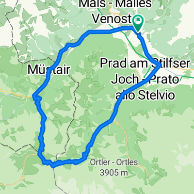
Overview
About this route
nomen est omen. You get on the Vinschgau train and ride to Schlunders, from there you go through the smallest town in Europe on a part of the 2008 Trans Alp route. But when the fun begins, we turn left onto the Zugtrail. And then just enjoy and ride the trails in a surfing manner. Un-believably good!
- -:--
- Duration
- 37.5 km
- Distance
- 699 m
- Ascent
- 958 m
- Descent
- ---
- Avg. speed
- ---
- Max. altitude

Continue with Bikemap
Use, edit, or download this cycling route
You would like to ride Zugtrail - Nordseite or customize it for your own trip? Here is what you can do with this Bikemap route:
Free features
- Save this route as favorite or in collections
- Copy & plan your own version of this route
- Sync your route with Garmin or Wahoo
Premium features
Free trial for 3 days, or one-time payment. More about Bikemap Premium.
- Navigate this route on iOS & Android
- Export a GPX / KML file of this route
- Create your custom printout (try it for free)
- Download this route for offline navigation
Discover more Premium features.
Get Bikemap PremiumFrom our community
Other popular routes starting in Schluderns
 65 Schluderns-Stilfserjoch-Umbrail-Schluderns
- Distance
- 65.1 km
- Ascent
- 1,883 m
- Descent
- 1,885 m
- Location
- Schluderns, Trentino-Alto Adige, Italy
 4. Etappe 20.07.2021 Schluderns nach Lana
- Distance
- 66.1 km
- Ascent
- 90 m
- Descent
- 734 m
- Location
- Schluderns, Trentino-Alto Adige, Italy
 Schnelle Radrunde vom 21. April, 18:13
- Distance
- 0.1 km
- Ascent
- 0 m
- Descent
- 0 m
- Location
- Schluderns, Trentino-Alto Adige, Italy
 Über den Reschenpass zum Arlberg
- Distance
- 97.6 km
- Ascent
- 1,453 m
- Descent
- 1,072 m
- Location
- Schluderns, Trentino-Alto Adige, Italy
 Schluderns-Reschen-Schöneben-Schluderns
- Distance
- 60.1 km
- Ascent
- 1,232 m
- Descent
- 1,230 m
- Location
- Schluderns, Trentino-Alto Adige, Italy
 Rundtour Lasa kurz
- Distance
- 19.1 km
- Ascent
- 97 m
- Descent
- 97 m
- Location
- Schluderns, Trentino-Alto Adige, Italy
 Reschensee
- Distance
- 52.2 km
- Ascent
- 747 m
- Descent
- 748 m
- Location
- Schluderns, Trentino-Alto Adige, Italy
 Schluderns bis Bassano del Grappa
- Distance
- 244.4 km
- Ascent
- 697 m
- Descent
- 1,519 m
- Location
- Schluderns, Trentino-Alto Adige, Italy
Open it in the app