

28/08
A cycling route starting in Malemort-sur-Corrèze, Nouvelle-Aquitaine, France.
Overview
About this route
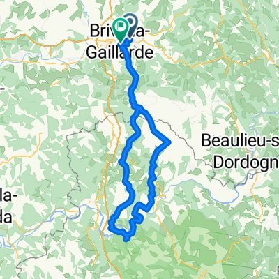
<!-- /* Style Definitions */ p.MsoNormal, li.MsoNormal, div.MsoNormal {mso-style-parent:""; margin:0cm; margin-bottom:.0001pt; mso-pagination:widow-orphan; font-size:12.0pt; font-family:"Times New Roman"; mso-fareast-font-family:"Times New Roman";} @page Section1 {size:612.0pt 792.0pt; margin:70.85pt 70.85pt 70.85pt 70.85pt; mso-header-margin:36.0pt; mso-footer-margin:36.0pt; mso-paper-source:0;} div.Section1 {page:Section1;} --> Brive – Rocher coupe – montplaisir – turenne – les 4 rtes – Martel – D23 Craysse – a droite d114 – St Sosy – D15 Meyronne – a droite d23 la cave – D43 – Le BelCastel – La treyne – Pinsac – A Droite D96 – Mayrac – D33 – Baladou – Cuzance – Hopital St Jean – Turenne – Brive
- -:--
- Duration
- 104.6 km
- Distance
- 872 m
- Ascent
- 865 m
- Descent
- ---
- Avg. speed
- ---
- Max. altitude
Continue with Bikemap
Use, edit, or download this cycling route
You would like to ride 28/08 or customize it for your own trip? Here is what you can do with this Bikemap route:
Free features
- Save this route as favorite or in collections
- Copy & plan your own version of this route
- Split it into stages to create a multi-day tour
- Sync your route with Garmin or Wahoo
Premium features
Free trial for 3 days, or one-time payment. More about Bikemap Premium.
- Navigate this route on iOS & Android
- Export a GPX / KML file of this route
- Create your custom printout (try it for free)
- Download this route for offline navigation
Discover more Premium features.
Get Bikemap PremiumFrom our community
Other popular routes starting in Malemort-sur-Corrèze
 85 km
85 km- Distance
- 86 km
- Ascent
- 1,173 m
- Descent
- 998 m
- Location
- Malemort-sur-Corrèze, Nouvelle-Aquitaine, France
 ucb 12/05/2011
- Distance
- 84.3 km
- Ascent
- 654 m
- Descent
- 655 m
- Location
- Malemort-sur-Corrèze, Nouvelle-Aquitaine, France
 28/08
28/08- Distance
- 104.6 km
- Ascent
- 872 m
- Descent
- 865 m
- Location
- Malemort-sur-Corrèze, Nouvelle-Aquitaine, France
 53 km
53 km- Distance
- 52.6 km
- Ascent
- 360 m
- Descent
- 364 m
- Location
- Malemort-sur-Corrèze, Nouvelle-Aquitaine, France
 8 mai 2010
- Distance
- 93.8 km
- Ascent
- 1,115 m
- Descent
- 1,112 m
- Location
- Malemort-sur-Corrèze, Nouvelle-Aquitaine, France
 ucb 5 mars 2011
- Distance
- 83.6 km
- Ascent
- 551 m
- Descent
- 548 m
- Location
- Malemort-sur-Corrèze, Nouvelle-Aquitaine, France
 ucb 26 11 2011
- Distance
- 56.3 km
- Ascent
- 655 m
- Descent
- 654 m
- Location
- Malemort-sur-Corrèze, Nouvelle-Aquitaine, France
 75 km
75 km- Distance
- 74.4 km
- Ascent
- 600 m
- Descent
- 598 m
- Location
- Malemort-sur-Corrèze, Nouvelle-Aquitaine, France
Open it in the app