

Shortcut to/and the extreme downhill path
A cycling route starting in Blagoevgrad, Blagoevgrad, Bulgaria.
Overview
About this route
Basically you ride up the neighborhood, around the left side of the zoo, to the rose garden then up the hill past the antennas and up the road.
When you reach the first trees, a place where the riders jump over the road, you can see on your left a stone painted in red paint. Throughout the path you will see such stones to show you the way. However, the first time, I suggest you take the path by foot or very slow.
After the first curve the path goes wildly down. The guys built some wild jumps, side-turns and everything that goes with downhill riding.
Since my skills are not very good, I was braking all the time, and still it was pretty tough for me to stay put on the ground. At the end you should jump a lot on the sides of the path to stay put. There are some pretty scary high jumps too.
Check out the photos on the map to get the idea.
Use good equipment and protection and scream!
- -:--
- Duration
- 1.1 km
- Distance
- 85 m
- Ascent
- 75 m
- Descent
- ---
- Avg. speed
- ---
- Max. altitude
Route highlights
Points of interest along the route

Photo after 0.5 km

Photo after 0.8 km

Photo after 0.8 km

Photo after 0.8 km
Start of the DH path

Photo after 0.8 km

Photo after 0.9 km

Photo after 0.9 km

Photo after 0.9 km

Photo after 0.9 km

Photo after 0.9 km

Photo after 1 km

Photo after 1 km
Crazy part here

Photo after 1 km
Very steep

Photo after 1.1 km
Nice

Photo after 1.1 km
The end
Continue with Bikemap
Use, edit, or download this cycling route
You would like to ride Shortcut to/and the extreme downhill path or customize it for your own trip? Here is what you can do with this Bikemap route:
Free features
- Save this route as favorite or in collections
- Copy & plan your own version of this route
- Sync your route with Garmin or Wahoo
Premium features
Free trial for 3 days, or one-time payment. More about Bikemap Premium.
- Navigate this route on iOS & Android
- Export a GPX / KML file of this route
- Create your custom printout (try it for free)
- Download this route for offline navigation
Discover more Premium features.
Get Bikemap PremiumFrom our community
Other popular routes starting in Blagoevgrad
 6 Macedonia
- Distance
- 122.3 km
- Ascent
- 1,142 m
- Descent
- 2,178 m
- Location
- Blagoevgrad, Blagoevgrad, Bulgaria
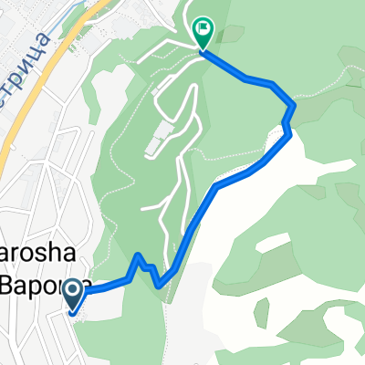 Shortcut to/and the extreme downhill path
- Distance
- 1.1 km
- Ascent
- 85 m
- Descent
- 75 m
- Location
- Blagoevgrad, Blagoevgrad, Bulgaria
 Blagoevgrad-Demirevo-Bistrica-Blagoevgrad CLONED FROM ROUTE 819503
- Distance
- 34 km
- Ascent
- 854 m
- Descent
- 858 m
- Location
- Blagoevgrad, Blagoevgrad, Bulgaria
 Dead end path with view on Bachinovo
- Distance
- 1.1 km
- Ascent
- 100 m
- Descent
- 57 m
- Location
- Blagoevgrad, Blagoevgrad, Bulgaria
 Blagoevgrad - Pehchevo
- Distance
- 62.3 km
- Ascent
- 1,386 m
- Descent
- 731 m
- Location
- Blagoevgrad, Blagoevgrad, Bulgaria
 Nice route to the near villas and back to Blago
- Distance
- 9.4 km
- Ascent
- 243 m
- Descent
- 213 m
- Location
- Blagoevgrad, Blagoevgrad, Bulgaria
 Notre parcours en Macédoine
- Distance
- 392.5 km
- Ascent
- 3,215 m
- Descent
- 2,575 m
- Location
- Blagoevgrad, Blagoevgrad, Bulgaria
 Scenic Route to Elenovo and back to Skapto
- Distance
- 8.8 km
- Ascent
- 283 m
- Descent
- 303 m
- Location
- Blagoevgrad, Blagoevgrad, Bulgaria
Open it in the app