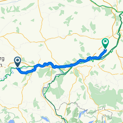
Brauereirunde mit Eis um Mühldorf
A cycling route starting in Mühldorf, Bavaria, Germany.
Overview
About this route
<p>MTB route with some not entirely easy trails. Otherwise gravel and secondary roads. No carry sections. Well doable with an eMTB. 2 breweries with beer gardens ;-) and great ice cream in Neuötting. The pilgrimage chapel of Altötting is worth seeing.</p>
<p>Start from the parking lot Stadtwall in Mühldorf am Inn.</p>
Translated, show original (German)- -:--
- Duration
- 41.1 km
- Distance
- 232 m
- Ascent
- 232 m
- Descent
- ---
- Avg. speed
- ---
- Max. altitude
Route quality
Waytypes & surfaces along the route
Waytypes
Quiet road
23 km
(56 %)
Track
9.9 km
(24 %)
Surfaces
Paved
26.3 km
(64 %)
Unpaved
11.1 km
(27 %)
Asphalt
25.9 km
(63 %)
Gravel
6.6 km
(16 %)
Route highlights
Points of interest along the route
Point of interest after 12.6 km
Bräu im Moos
Point of interest after 21.2 km
Brauerei Graminger
Point of interest after 25.2 km
Eiscafe Dolomiti
Continue with Bikemap
Use, edit, or download this cycling route
You would like to ride Brauereirunde mit Eis um Mühldorf or customize it for your own trip? Here is what you can do with this Bikemap route:
Free features
- Save this route as favorite or in collections
- Copy & plan your own version of this route
- Sync your route with Garmin or Wahoo
Premium features
Free trial for 3 days, or one-time payment. More about Bikemap Premium.
- Navigate this route on iOS & Android
- Export a GPX / KML file of this route
- Create your custom printout (try it for free)
- Download this route for offline navigation
Discover more Premium features.
Get Bikemap PremiumFrom our community
Other popular routes starting in Mühldorf
- Rundkurs durchn Wald
- Distance
- 52.4 km
- Ascent
- 401 m
- Descent
- 401 m
- Location
- Mühldorf, Bavaria, Germany
- Einfahren MTB
- Distance
- 23.7 km
- Ascent
- 139 m
- Descent
- 140 m
- Location
- Mühldorf, Bavaria, Germany
- 2 - Mühldorf, Garching, Altötting
- Distance
- 52.2 km
- Ascent
- 184 m
- Descent
- 183 m
- Location
- Mühldorf, Bavaria, Germany
- Tagestour Mühldorf am Inn - Passau
- Distance
- 94.1 km
- Ascent
- 533 m
- Descent
- 637 m
- Location
- Mühldorf, Bavaria, Germany
- Mühldorf
- Distance
- 73.9 km
- Ascent
- 222 m
- Descent
- 222 m
- Location
- Mühldorf, Bavaria, Germany
- 42_Mühldorf – Simbach/Braunau
- Distance
- 50.2 km
- Ascent
- 69 m
- Descent
- 109 m
- Location
- Mühldorf, Bavaria, Germany
- Laufrunde
- Distance
- 6.6 km
- Ascent
- 46 m
- Descent
- 48 m
- Location
- Mühldorf, Bavaria, Germany
- Benediktweg, 1. Etappe, Mühldorf-Waldkraiburg vv
- Distance
- 38 km
- Ascent
- 1,588 m
- Descent
- 1,514 m
- Location
- Mühldorf, Bavaria, Germany
Open it in the app