

Ohau-Natzschung-Kühnhaide-Rätzteich-MAB-Pockau-Ohau
A cycling route starting in Olbernhau, Saxony, Germany.
Overview
About this route
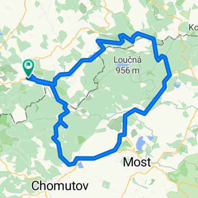
Very nice training round through the Natzschung Valley to Kühnhaide - a scenically brilliant connecting road to the B174 - down to Gelobtland - enjoyment sunshine at Räzteich - return via Marienberg, Hüttengrund, along the Schwarze Pockau to Pockau and in the Flöhatal back to Olbernhau.
- -:--
- Duration
- 60 km
- Distance
- 502 m
- Ascent
- 502 m
- Descent
- ---
- Avg. speed
- ---
- Max. altitude

Continue with Bikemap
Use, edit, or download this cycling route
You would like to ride Ohau-Natzschung-Kühnhaide-Rätzteich-MAB-Pockau-Ohau or customize it for your own trip? Here is what you can do with this Bikemap route:
Free features
- Save this route as favorite or in collections
- Copy & plan your own version of this route
- Sync your route with Garmin or Wahoo
Premium features
Free trial for 3 days, or one-time payment. More about Bikemap Premium.
- Navigate this route on iOS & Android
- Export a GPX / KML file of this route
- Create your custom printout (try it for free)
- Download this route for offline navigation
Discover more Premium features.
Get Bikemap PremiumFrom our community
Other popular routes starting in Olbernhau
 Stürmer und Lesna
- Distance
- 119 km
- Ascent
- 1,241 m
- Descent
- 1,241 m
- Location
- Olbernhau, Saxony, Germany
 Erzgebirge - 1.000 hm Anstieg & härtester Sachsens
- Distance
- 251.2 km
- Ascent
- 2,045 m
- Descent
- 2,045 m
- Location
- Olbernhau, Saxony, Germany
 Ohau - Rabenberg "STK 08"
- Distance
- 73.2 km
- Ascent
- 1,421 m
- Descent
- 967 m
- Location
- Olbernhau, Saxony, Germany
 Erzgebirgsquartett
- Distance
- 213.8 km
- Ascent
- 3,903 m
- Descent
- 3,814 m
- Location
- Olbernhau, Saxony, Germany
 Ohau-Sayda-Neuhausen-Schwartenberg-D´neudorf-Ohau
- Distance
- 44.5 km
- Ascent
- 672 m
- Descent
- 671 m
- Location
- Olbernhau, Saxony, Germany
 Ohau-Rungstock-Schwarzwassertal-Natzschungtal-Ohau
- Distance
- 46.7 km
- Ascent
- 641 m
- Descent
- 641 m
- Location
- Olbernhau, Saxony, Germany
 Geheimtip !!!
- Distance
- 60.2 km
- Ascent
- 879 m
- Descent
- 879 m
- Location
- Olbernhau, Saxony, Germany
 Ohau-Sayda-Clausnitz-Neuhausen-Ohau
- Distance
- 44.6 km
- Ascent
- 563 m
- Descent
- 571 m
- Location
- Olbernhau, Saxony, Germany
Open it in the app