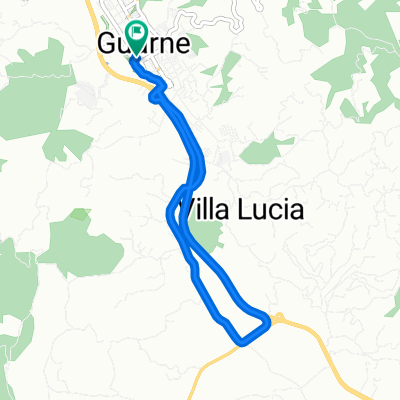
De Vía Vereda San Isidro a Vía Parque Arví
A cycling route starting in Guarne, Antioquia, Colombia.
Overview
About this route
- 3 h
- Duration
- 17.8 km
- Distance
- 422 m
- Ascent
- 405 m
- Descent
- 5.9 km/h
- Avg. speed
- ---
- Max. altitude
Route quality
Waytypes & surfaces along the route
Waytypes
Quiet road
10.6 km
(60 %)
Road
6.6 km
(37 %)
Surfaces
Paved
5.8 km
(33 %)
Unpaved
3.1 km
(18 %)
Asphalt
5.7 km
(32 %)
Unpaved (undefined)
3.1 km
(18 %)
Continue with Bikemap
Use, edit, or download this cycling route
You would like to ride De Vía Vereda San Isidro a Vía Parque Arví or customize it for your own trip? Here is what you can do with this Bikemap route:
Free features
- Save this route as favorite or in collections
- Copy & plan your own version of this route
- Sync your route with Garmin or Wahoo
Premium features
Free trial for 3 days, or one-time payment. More about Bikemap Premium.
- Navigate this route on iOS & Android
- Export a GPX / KML file of this route
- Create your custom printout (try it for free)
- Download this route for offline navigation
Discover more Premium features.
Get Bikemap PremiumFrom our community
Other popular routes starting in Guarne
- De Vía Vereda San Isidro a represa santa Elena san Isidro
- Distance
- 20.3 km
- Ascent
- 712 m
- Descent
- 725 m
- Location
- Guarne, Antioquia, Colombia
- Parque Arvi @ Medellin
- Distance
- 14.5 km
- Ascent
- 324 m
- Descent
- 324 m
- Location
- Guarne, Antioquia, Colombia
- El Aleman.. El Aguila .. Las Brujas.. Chaparral..
- Distance
- 41.6 km
- Ascent
- 997 m
- Descent
- 997 m
- Location
- Guarne, Antioquia, Colombia
- Vereda San Isidro ,laguna, mirador , mazo ,el tambo
- Distance
- 21.9 km
- Ascent
- 548 m
- Descent
- 559 m
- Location
- Guarne, Antioquia, Colombia
- Finca Edilma....
- Distance
- 14.3 km
- Ascent
- 440 m
- Descent
- 356 m
- Location
- Guarne, Antioquia, Colombia
- manpuesto
- Distance
- 18.8 km
- Ascent
- 379 m
- Descent
- 361 m
- Location
- Guarne, Antioquia, Colombia
- De Vía Vereda San Isidro a Vía Parque Arví
- Distance
- 17.8 km
- Ascent
- 422 m
- Descent
- 405 m
- Location
- Guarne, Antioquia, Colombia
- El Aleman .. El sango .. La Brizuela ..
- Distance
- 14.9 km
- Ascent
- 543 m
- Descent
- 544 m
- Location
- Guarne, Antioquia, Colombia
Open it in the app