Skæring 20.07
A cycling route starting in Hjortshøj, Central Jutland, Denmark.
Overview
About this route
- -:--
- Duration
- 32.2 km
- Distance
- 169 m
- Ascent
- 175 m
- Descent
- ---
- Avg. speed
- ---
- Max. altitude
Route quality
Waytypes & surfaces along the route
Waytypes
Quiet road
14.5 km
(45 %)
Road
6.1 km
(19 %)
Surfaces
Paved
23.5 km
(73 %)
Unpaved
7.7 km
(24 %)
Asphalt
23.5 km
(73 %)
Gravel
7.7 km
(24 %)
Undefined
1 km
(3 %)
Continue with Bikemap
Use, edit, or download this cycling route
You would like to ride Skæring 20.07 or customize it for your own trip? Here is what you can do with this Bikemap route:
Free features
- Save this route as favorite or in collections
- Copy & plan your own version of this route
- Sync your route with Garmin or Wahoo
Premium features
Free trial for 3 days, or one-time payment. More about Bikemap Premium.
- Navigate this route on iOS & Android
- Export a GPX / KML file of this route
- Create your custom printout (try it for free)
- Download this route for offline navigation
Discover more Premium features.
Get Bikemap PremiumFrom our community
Other popular routes starting in Hjortshøj
Skæring 20.07- Distance
- 32.2 km
- Ascent
- 169 m
- Descent
- 175 m
- Location
- Hjortshøj, Central Jutland, Denmark
Hummel Hummel "Mols" "Mols"- Distance
- 41.4 km
- Ascent
- 243 m
- Descent
- 228 m
- Location
- Hjortshøj, Central Jutland, Denmark
Skæring Nord 9.07- Distance
- 21.9 km
- Ascent
- 135 m
- Descent
- 139 m
- Location
- Hjortshøj, Central Jutland, Denmark
Skødstrup - Risskov- Distance
- 17.8 km
- Ascent
- 49 m
- Descent
- 27 m
- Location
- Hjortshøj, Central Jutland, Denmark
Da Skæring Havvej a Vosnæsparken- Distance
- 7.8 km
- Ascent
- 66 m
- Descent
- 57 m
- Location
- Hjortshøj, Central Jutland, Denmark
Hjortshøj til Fjellerup- Distance
- 55 km
- Ascent
- 252 m
- Descent
- 270 m
- Location
- Hjortshøj, Central Jutland, Denmark
sommer 2023- Distance
- 258.1 km
- Ascent
- 1,053 m
- Descent
- 1,061 m
- Location
- Hjortshøj, Central Jutland, Denmark
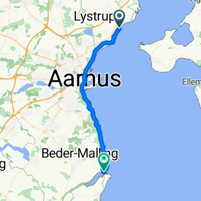
Skæring Strandvej 44, Egå do Stavneagervej 41B, Egå- Distance
- 30.1 km
- Ascent
- 134 m
- Descent
- 132 m
- Location
- Hjortshøj, Central Jutland, Denmark
Open it in the app

