
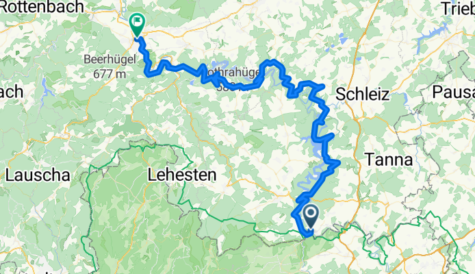
3 - Blakenstein - Saalfeld - 90K
A cycling route starting in Blankenstein, Thuringia, Germany.
Overview
About this route
3 - Blakenstein - Saalfeld - 90K - 1,5H
Naturpark Thüringen - Schiefergebirge
- -:--
- Duration
- 92.9 km
- Distance
- 1,954 m
- Ascent
- 2,175 m
- Descent
- ---
- Avg. speed
- ---
- Max. altitude

Route photos


Route quality
Waytypes & surfaces along the route
Waytypes
Quiet road
22.3 km
(24 %)
Road
19.5 km
(21 %)
Surfaces
Paved
72.5 km
(78 %)
Unpaved
5.6 km
(6 %)
Asphalt
69.7 km
(75 %)
Gravel
4.6 km
(5 %)
Continue with Bikemap
Use, edit, or download this cycling route
You would like to ride 3 - Blakenstein - Saalfeld - 90K or customize it for your own trip? Here is what you can do with this Bikemap route:
Free features
- Save this route as favorite or in collections
- Copy & plan your own version of this route
- Split it into stages to create a multi-day tour
- Sync your route with Garmin or Wahoo
Premium features
Free trial for 3 days, or one-time payment. More about Bikemap Premium.
- Navigate this route on iOS & Android
- Export a GPX / KML file of this route
- Create your custom printout (try it for free)
- Download this route for offline navigation
Discover more Premium features.
Get Bikemap PremiumFrom our community
Other popular routes starting in Blankenstein
 Höllental (Blankenstein)
- Distance
- 10.5 km
- Ascent
- 248 m
- Descent
- 248 m
- Location
- Blankenstein, Thuringia, Germany
 SRW_Etappe3
- Distance
- 38.4 km
- Ascent
- 528 m
- Descent
- 635 m
- Location
- Blankenstein, Thuringia, Germany
 Rennsteigradweg u. Frankenwaldhochstr.
- Distance
- 61.4 km
- Ascent
- 897 m
- Descent
- 910 m
- Location
- Blankenstein, Thuringia, Germany
 Rennsteig: Blankenstein - Hörschel
- Distance
- 165 km
- Ascent
- 1,273 m
- Descent
- 1,497 m
- Location
- Blankenstein, Thuringia, Germany
 3. Etappe Blankenstein - Neudietendorf
- Distance
- 141.9 km
- Ascent
- 1,093 m
- Descent
- 1,294 m
- Location
- Blankenstein, Thuringia, Germany
 RSSL_2012_1
- Distance
- 16.7 km
- Ascent
- 401 m
- Descent
- 120 m
- Location
- Blankenstein, Thuringia, Germany
 3 - Blakenstein - Saalfeld - 90K
- Distance
- 92.9 km
- Ascent
- 1,954 m
- Descent
- 2,175 m
- Location
- Blankenstein, Thuringia, Germany
 Rennsteig Radweg (entgegen der klassichen Richtung)
- Distance
- 184.4 km
- Ascent
- 1,249 m
- Descent
- 1,413 m
- Location
- Blankenstein, Thuringia, Germany
Open it in the app