

Wąchock - Wykus Szlakiem Niebieskim
A cycling route starting in Wąchock, Świętokrzyskie Voivodship, Poland.
Overview
About this route
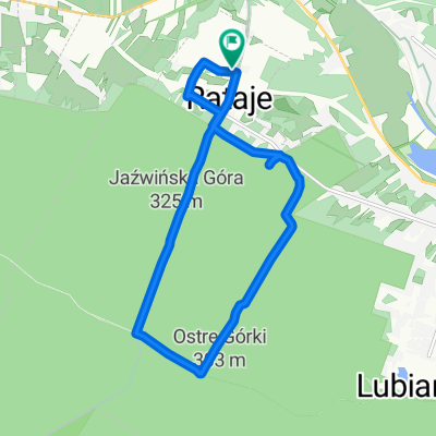
Wąchock - Rataje - Fire Watch Tower - Langiewicz Glade - Way of the Cross - Monument - Lubianka River - Grave - Grave - Wykus Glade - Wąchock Apparition
- -:--
- Duration
- 20.8 km
- Distance
- 297 m
- Ascent
- 297 m
- Descent
- ---
- Avg. speed
- ---
- Max. altitude

Route quality
Waytypes & surfaces along the route
Waytypes
Quiet road
8.3 km
(40 %)
Path
5 km
(24 %)
Surfaces
Paved
3.8 km
(18 %)
Unpaved
3.1 km
(15 %)
Asphalt
3.5 km
(17 %)
Ground
2.5 km
(12 %)
Continue with Bikemap
Use, edit, or download this cycling route
You would like to ride Wąchock - Wykus Szlakiem Niebieskim or customize it for your own trip? Here is what you can do with this Bikemap route:
Free features
- Save this route as favorite or in collections
- Copy & plan your own version of this route
- Sync your route with Garmin or Wahoo
Premium features
Free trial for 3 days, or one-time payment. More about Bikemap Premium.
- Navigate this route on iOS & Android
- Export a GPX / KML file of this route
- Create your custom printout (try it for free)
- Download this route for offline navigation
Discover more Premium features.
Get Bikemap PremiumFrom our community
Other popular routes starting in Wąchock
 Rowerowy szlak dookoła Strachowic
- Distance
- 61.3 km
- Ascent
- 418 m
- Descent
- 418 m
- Location
- Wąchock, Świętokrzyskie Voivodship, Poland
 Wąchock - Wykus Szlakiem Niebieskim
- Distance
- 20.8 km
- Ascent
- 297 m
- Descent
- 297 m
- Location
- Wąchock, Świętokrzyskie Voivodship, Poland
 7.08.2021
- Distance
- 6.2 km
- Ascent
- 5 m
- Descent
- 0 m
- Location
- Wąchock, Świętokrzyskie Voivodship, Poland
 Kielecczyzna
- Distance
- 35.3 km
- Ascent
- 364 m
- Descent
- 217 m
- Location
- Wąchock, Świętokrzyskie Voivodship, Poland
 Pętla Świętokrzyska 5
- Distance
- 118.1 km
- Ascent
- 1,191 m
- Descent
- 1,194 m
- Location
- Wąchock, Świętokrzyskie Voivodship, Poland
 Julia Dwojewska w-f
- Distance
- 10.5 km
- Ascent
- 20 m
- Descent
- 4 m
- Location
- Wąchock, Świętokrzyskie Voivodship, Poland
 Jazda na rowerze wf
- Distance
- 11.2 km
- Ascent
- 233 m
- Descent
- 214 m
- Location
- Wąchock, Świętokrzyskie Voivodship, Poland
 tst
tst- Distance
- 38.9 km
- Ascent
- 378 m
- Descent
- 345 m
- Location
- Wąchock, Świętokrzyskie Voivodship, Poland
Open it in the app