

mongram
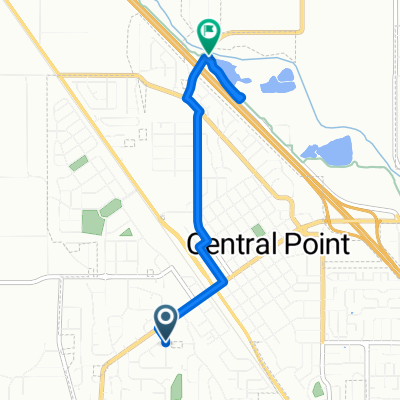
A cycling route starting in Central Point, Oregon, United States.
Overview
About this route
monogram
- -:--
- Duration
- 52.4 km
- Distance
- 1,403 m
- Ascent
- 653 m
- Descent
- ---
- Avg. speed
- ---
- Max. altitude
Route highlights
Points of interest along the route
Point of interest after 43.9 km
Point of interest after 43.9 km
Bridge
Point of interest after 43.9 km
Point of interest after 43.9 km
Point of interest after 43.9 km
Point of interest after 43.9 km
Point of interest after 45.6 km
Point of interest after 45.6 km
Continue with Bikemap
Use, edit, or download this cycling route
You would like to ride mongram or customize it for your own trip? Here is what you can do with this Bikemap route:
Free features
- Save this route as favorite or in collections
- Copy & plan your own version of this route
- Sync your route with Garmin or Wahoo
Premium features
Free trial for 3 days, or one-time payment. More about Bikemap Premium.
- Navigate this route on iOS & Android
- Export a GPX / KML file of this route
- Create your custom printout (try it for free)
- Download this route for offline navigation
Discover more Premium features.
Get Bikemap PremiumFrom our community
Other popular routes starting in Central Point
 201 Corcoran Ln, Central Point to 99 Peninger Rd, Central Point
- Distance
- 3.7 km
- Ascent
- 0 m
- Descent
- 16 m
- Location
- Central Point, Oregon, United States
 201 Corcoran Ln, Central Point to 3128–3182 Juanipero Way, Medford
- Distance
- 13.3 km
- Ascent
- 70 m
- Descent
- 8 m
- Location
- Central Point, Oregon, United States
 Elk Street 81, Medford to Peachwood Court 1168, Medford
- Distance
- 7.3 km
- Ascent
- 45 m
- Descent
- 0 m
- Location
- Central Point, Oregon, United States
 288 Lavender Ln, Central Point to 288 Lavender Ln, Central Point
- Distance
- 18.8 km
- Ascent
- 51 m
- Descent
- 52 m
- Location
- Central Point, Oregon, United States
 288 Lavender Ln, Central Point to 288 Lavender Ln, Central Point
- Distance
- 20.7 km
- Ascent
- 47 m
- Descent
- 48 m
- Location
- Central Point, Oregon, United States
 mongram
- Distance
- 52.4 km
- Ascent
- 1,403 m
- Descent
- 653 m
- Location
- Central Point, Oregon, United States
 Bear Creek Greenway, Central Point to Bear Creek Greenway, Central Point
- Distance
- 22.4 km
- Ascent
- 79 m
- Descent
- 83 m
- Location
- Central Point, Oregon, United States
 Pumphouse Beer Ride
- Distance
- 21.6 km
- Ascent
- 111 m
- Descent
- 0 m
- Location
- Central Point, Oregon, United States
Open it in the app