

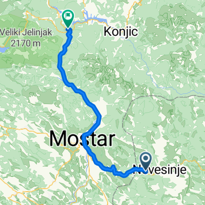
Nevesinje - Podvelež - Mostar
A cycling route starting in Nevesinje, Republika Srpska, Bosnia and Herzegovina.
Overview
About this route
A short 4 km climb from Nevesinje, followed by a long descent up to the point where you turn right, with a short climb to Podvelež, and finally a superb descent from Podveležje to Mostar. A short but very sweet ride.
- -:--
- Duration
- 45.6 km
- Distance
- 532 m
- Ascent
- 1,366 m
- Descent
- ---
- Avg. speed
- ---
- Max. altitude
Route quality
Waytypes & surfaces along the route
Waytypes
Road
25.5 km
(56 %)
Quiet road
2.3 km
(5 %)
Undefined
17.8 km
(39 %)
Surfaces
Paved
43.8 km
(96 %)
Asphalt
43.8 km
(96 %)
Undefined
1.8 km
(4 %)
Continue with Bikemap
Use, edit, or download this cycling route
You would like to ride Nevesinje - Podvelež - Mostar or customize it for your own trip? Here is what you can do with this Bikemap route:
Free features
- Save this route as favorite or in collections
- Copy & plan your own version of this route
- Sync your route with Garmin or Wahoo
Premium features
Free trial for 3 days, or one-time payment. More about Bikemap Premium.
- Navigate this route on iOS & Android
- Export a GPX / KML file of this route
- Create your custom printout (try it for free)
- Download this route for offline navigation
Discover more Premium features.
Get Bikemap PremiumFrom our community
Other popular routes starting in Nevesinje
 Odzak Ruista Potoci
- Distance
- 64.1 km
- Ascent
- 710 m
- Descent
- 1,489 m
- Location
- Nevesinje, Republika Srpska, Bosnia and Herzegovina
 Odzak Konjic via Krusevljani
- Distance
- 68.9 km
- Ascent
- 775 m
- Descent
- 1,374 m
- Location
- Nevesinje, Republika Srpska, Bosnia and Herzegovina
 Nevesinje-Mostar-Split
- Distance
- 205.1 km
- Ascent
- 1,472 m
- Descent
- 2,284 m
- Location
- Nevesinje, Republika Srpska, Bosnia and Herzegovina
 jezero konjic
- Distance
- 97.5 km
- Ascent
- 1,341 m
- Descent
- 2,127 m
- Location
- Nevesinje, Republika Srpska, Bosnia and Herzegovina
 mdutvonal11
- Distance
- 62.9 km
- Ascent
- 441 m
- Descent
- 1,170 m
- Location
- Nevesinje, Republika Srpska, Bosnia and Herzegovina
 ewrr ewr ewr
- Distance
- 116.9 km
- Ascent
- 1,205 m
- Descent
- 1,589 m
- Location
- Nevesinje, Republika Srpska, Bosnia and Herzegovina
 D2011 R30
- Distance
- 75 km
- Ascent
- 652 m
- Descent
- 1,414 m
- Location
- Nevesinje, Republika Srpska, Bosnia and Herzegovina
 Plužine - Sarajevo (via Trnovo)
- Distance
- 100.2 km
- Ascent
- 875 m
- Descent
- 1,599 m
- Location
- Nevesinje, Republika Srpska, Bosnia and Herzegovina
Open it in the app