
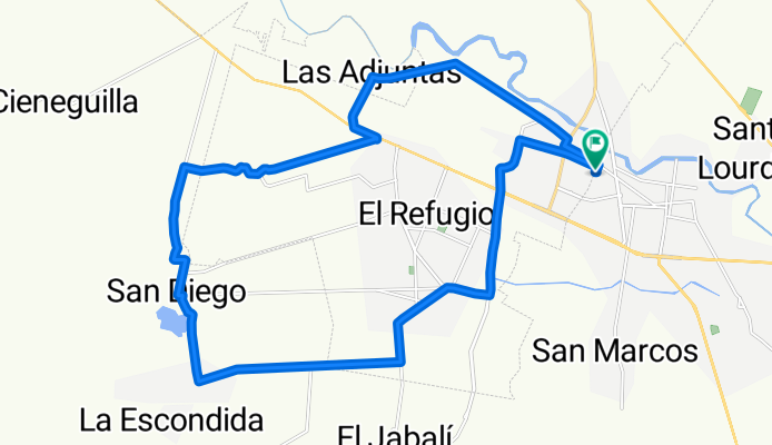
Rodada Adjuntas-La Loma
A cycling route starting in Ciudad Fernández, San Luis Potosí, Mexico.
Overview
About this route
- 2 h 22 min
- Duration
- 32.7 km
- Distance
- 158 m
- Ascent
- 157 m
- Descent
- 13.9 km/h
- Avg. speed
- ---
- Max. altitude

Route photos

Route quality
Waytypes & surfaces along the route
Waytypes
Road
21.3 km
(65 %)
Quiet road
7.5 km
(23 %)
Undefined
3.9 km
(12 %)
Surfaces
Paved
14.7 km
(45 %)
Unpaved
3.6 km
(11 %)
Asphalt
9.5 km
(29 %)
Paved (undefined)
5.2 km
(16 %)
Continue with Bikemap
Use, edit, or download this cycling route
You would like to ride Rodada Adjuntas-La Loma or customize it for your own trip? Here is what you can do with this Bikemap route:
Free features
- Save this route as favorite or in collections
- Copy & plan your own version of this route
- Sync your route with Garmin or Wahoo
Premium features
Free trial for 3 days, or one-time payment. More about Bikemap Premium.
- Navigate this route on iOS & Android
- Export a GPX / KML file of this route
- Create your custom printout (try it for free)
- Download this route for offline navigation
Discover more Premium features.
Get Bikemap PremiumFrom our community
Other popular routes starting in Ciudad Fernández
 Rodada Adjuntas-La Loma
- Distance
- 32.7 km
- Ascent
- 158 m
- Descent
- 157 m
- Location
- Ciudad Fernández, San Luis Potosí, Mexico
 De Calle José María Morelos y Pavón 504, Ciudad Fernández a Calle José María Morelos y Pavón 435, Ciudad Fernández
- Distance
- 17.9 km
- Ascent
- 59 m
- Descent
- 60 m
- Location
- Ciudad Fernández, San Luis Potosí, Mexico
 Chivato
- Distance
- 6 km
- Ascent
- 213 m
- Descent
- 215 m
- Location
- Ciudad Fernández, San Luis Potosí, Mexico
 De Calle Centenario, Ciudad Fernández a Séptima Privada Centenario 98–106, Huerta José González
- Distance
- 19.1 km
- Ascent
- 31 m
- Descent
- 28 m
- Location
- Ciudad Fernández, San Luis Potosí, Mexico
 Lugar tranquilo
- Distance
- 6.4 km
- Ascent
- 12 m
- Descent
- 9 m
- Location
- Ciudad Fernández, San Luis Potosí, Mexico
 De Calle Frontera 402A, Rioverde a Calle Frontera 402A, Rioverde
- Distance
- 15.5 km
- Ascent
- 83 m
- Descent
- 84 m
- Location
- Ciudad Fernández, San Luis Potosí, Mexico
 Ruta constante en Huerta José González
- Distance
- 20.8 km
- Ascent
- 76 m
- Descent
- 78 m
- Location
- Ciudad Fernández, San Luis Potosí, Mexico
 Rodada al Ojo de Agua Seco
- Distance
- 33.8 km
- Ascent
- 148 m
- Descent
- 147 m
- Location
- Ciudad Fernández, San Luis Potosí, Mexico
Open it in the app