

canal de gravedad
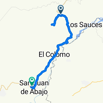
A cycling route starting in San Juan de Abajo, Nayarit, Mexico.
Overview
About this route
- 2 h 5 min
- Duration
- 19.2 km
- Distance
- 49 m
- Ascent
- 75 m
- Descent
- 9.2 km/h
- Avg. speed
- ---
- Max. altitude

Route photos

Continue with Bikemap
Use, edit, or download this cycling route
You would like to ride canal de gravedad or customize it for your own trip? Here is what you can do with this Bikemap route:
Free features
- Save this route as favorite or in collections
- Copy & plan your own version of this route
- Sync your route with Garmin or Wahoo
Premium features
Free trial for 3 days, or one-time payment. More about Bikemap Premium.
- Navigate this route on iOS & Android
- Export a GPX / KML file of this route
- Create your custom printout (try it for free)
- Download this route for offline navigation
Discover more Premium features.
Get Bikemap PremiumFrom our community
Other popular routes starting in San Juan de Abajo
 Bici Bucerias Bakery Ride - Climbing La Sierra Madre - Bici Bucerias Bakery Ride - Climbing La Sierra Madre
- Distance
- 62.7 km
- Ascent
- 1,366 m
- Descent
- 1,367 m
- Location
- San Juan de Abajo, Nayarit, Mexico
 el chorrito- el colomo- San Juan
- Distance
- 24.2 km
- Ascent
- 11 m
- Descent
- 39 m
- Location
- San Juan de Abajo, Nayarit, Mexico
 huchichila, valle de banderas-San Juan de abajo Nayarit
- Distance
- 19.9 km
- Ascent
- 111 m
- Descent
- 105 m
- Location
- San Juan de Abajo, Nayarit, Mexico
 Calle 5 de Mayo 15, Bahía de Banderas to Avenida Lázaro Cárdenas 129, Bahía de Banderas
- Distance
- 19.1 km
- Ascent
- 99 m
- Descent
- 99 m
- Location
- San Juan de Abajo, Nayarit, Mexico
 Victoria Anaya Tovar 61, San Juan de Abajo to Victoria Anaya Tovar 61, San Juan de Abajo
- Distance
- 20 km
- Ascent
- 69 m
- Descent
- 49 m
- Location
- San Juan de Abajo, Nayarit, Mexico
 De Calle Venustiano Carranza, Bahía de Banderas a Calle 5 de Mayo 18, Bahía de Banderas
- Distance
- 18.2 km
- Ascent
- 200 m
- Descent
- 201 m
- Location
- San Juan de Abajo, Nayarit, Mexico
 Route to Calle José María Morelos 42, Bahía de Banderas
- Distance
- 27.7 km
- Ascent
- 61 m
- Descent
- 142 m
- Location
- San Juan de Abajo, Nayarit, Mexico
 Jardines - La presa
- Distance
- 32.1 km
- Ascent
- 142 m
- Descent
- 145 m
- Location
- San Juan de Abajo, Nayarit, Mexico
Open it in the app