
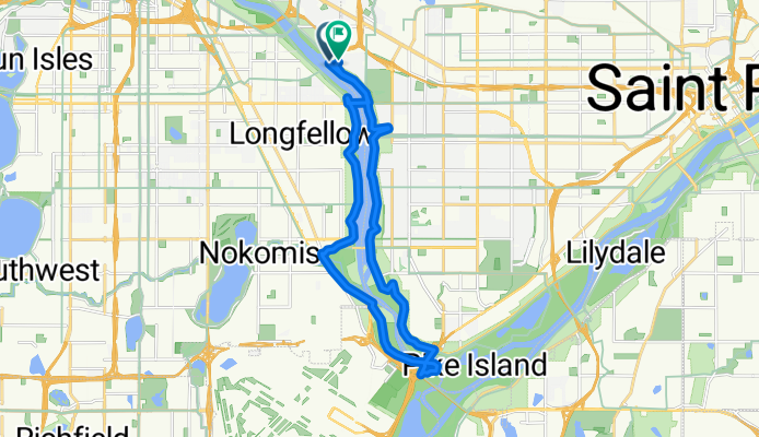
Fort Snelling Loop
A cycling route starting in Lauderdale, Minnesota, United States.
Overview
About this route
Bumpy trails along the river to Fort Snelling, smooth trails the rest of the way.
- -:--
- Duration
- 20.9 km
- Distance
- 169 m
- Ascent
- 154 m
- Descent
- ---
- Avg. speed
- ---
- Max. altitude

Route quality
Waytypes & surfaces along the route
Waytypes
Cycleway
16.1 km
(77 %)
Road
2.3 km
(11 %)
Surfaces
Paved
18.9 km
(90 %)
Asphalt
10.7 km
(51 %)
Paved (undefined)
7.7 km
(37 %)
Continue with Bikemap
Use, edit, or download this cycling route
You would like to ride Fort Snelling Loop or customize it for your own trip? Here is what you can do with this Bikemap route:
Free features
- Save this route as favorite or in collections
- Copy & plan your own version of this route
- Sync your route with Garmin or Wahoo
Premium features
Free trial for 3 days, or one-time payment. More about Bikemap Premium.
- Navigate this route on iOS & Android
- Export a GPX / KML file of this route
- Create your custom printout (try it for free)
- Download this route for offline navigation
Discover more Premium features.
Get Bikemap PremiumFrom our community
Other popular routes starting in Lauderdale
 B2B 00003: 55114 to 55407 via Franklin, Greenway
- Distance
- 8.7 km
- Ascent
- 43 m
- Descent
- 52 m
- Location
- Lauderdale, Minnesota, United States
 Fort Snelling Loop
- Distance
- 20.9 km
- Ascent
- 169 m
- Descent
- 154 m
- Location
- Lauderdale, Minnesota, United States
 B2B00715 55406 > 55402 via Midtown Greenway, Park Ave
- Distance
- 9 km
- Ascent
- 15 m
- Descent
- 3 m
- Location
- Lauderdale, Minnesota, United States
 B2B 55114 > 55411 via UMN Transitway, West River Road
- Distance
- 8 km
- Ascent
- 66 m
- Descent
- 87 m
- Location
- Lauderdale, Minnesota, United States
 B2B00900 55113>55104 via Fairview Av, Como Av
- Distance
- 10.1 km
- Ascent
- 22 m
- Descent
- 36 m
- Location
- Lauderdale, Minnesota, United States
 B2B00051 55108>55345 via CLT, SWLRT Trls
- Distance
- 27.8 km
- Ascent
- 128 m
- Descent
- 94 m
- Location
- Lauderdale, Minnesota, United States
 Como Ave, Saint Paul to Estabrook Dr, Saint Paul
- Distance
- 4.8 km
- Ascent
- 25 m
- Descent
- 25 m
- Location
- Lauderdale, Minnesota, United States
 From Minneapolis to Saint Paul
- Distance
- 8.8 km
- Ascent
- 57 m
- Descent
- 49 m
- Location
- Lauderdale, Minnesota, United States
Open it in the app