
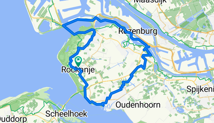
53-Hellevoetsluis
A cycling route starting in Nieuwenhoorn, South Holland, The Netherlands.
Overview
About this route
- -:--
- Duration
- 52.6 km
- Distance
- 31 m
- Ascent
- 31 m
- Descent
- ---
- Avg. speed
- ---
- Max. altitude
Continue with Bikemap
Use, edit, or download this cycling route
You would like to ride 53-Hellevoetsluis or customize it for your own trip? Here is what you can do with this Bikemap route:
Free features
- Save this route as favorite or in collections
- Copy & plan your own version of this route
- Sync your route with Garmin or Wahoo
Premium features
Free trial for 3 days, or one-time payment. More about Bikemap Premium.
- Navigate this route on iOS & Android
- Export a GPX / KML file of this route
- Create your custom printout (try it for free)
- Download this route for offline navigation
Discover more Premium features.
Get Bikemap PremiumFrom our community
Other popular routes starting in Nieuwenhoorn
 Do 04,07 Anreise
- Distance
- 42.7 km
- Ascent
- 51 m
- Descent
- 54 m
- Location
- Nieuwenhoorn, South Holland, The Netherlands
 Jour 08
- Distance
- 50 km
- Ascent
- 66 m
- Descent
- 64 m
- Location
- Nieuwenhoorn, South Holland, The Netherlands
 Brielle - Rokanje
- Distance
- 36.8 km
- Ascent
- 31 m
- Descent
- 31 m
- Location
- Nieuwenhoorn, South Holland, The Netherlands
 Rondje Rockanje
- Distance
- 38 km
- Ascent
- 13 m
- Descent
- 13 m
- Location
- Nieuwenhoorn, South Holland, The Netherlands
 53-Hellevoetsluis
- Distance
- 52.6 km
- Ascent
- 31 m
- Descent
- 31 m
- Location
- Nieuwenhoorn, South Holland, The Netherlands
 Z: Bruggen, dammen en sluizen
- Distance
- 143.7 km
- Ascent
- 15 m
- Descent
- 13 m
- Location
- Nieuwenhoorn, South Holland, The Netherlands
 Sportieve route in Hellevoetsluis
- Distance
- 41.5 km
- Ascent
- 32 m
- Descent
- 28 m
- Location
- Nieuwenhoorn, South Holland, The Netherlands
 Duinrand nach N15
- Distance
- 13.6 km
- Ascent
- 26 m
- Descent
- 27 m
- Location
- Nieuwenhoorn, South Holland, The Netherlands
Open it in the app