

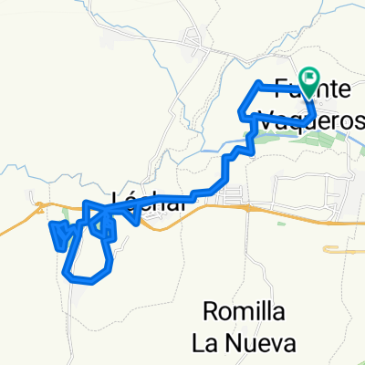
31-8-10 F.Vaqueros-Láchar-Peñuelas-C.Tajarja-Chimeneas-S.Catalina-P.Periurbano-Jau (IBP:67)
A cycling route starting in Fuente Vaqueros, Andalusia, Spain.
Overview
About this route
Training route. Headwind for nearly the entire stretch (up to the turn for the Cortijo de Santa Catalina), the muggy heat with the warm clouds and the desire to increase my average despite everything have punished me today in a way that is not normal for this route, which has no difficulty aside from the total length and the heat of the drylands in that area. Mostly on asphalt (from Cijuela to the turn for the Cortijo de Santa Catalina, it's all asphalt, but very, very quiet, that’s for sure), but the end is a path. I wanted to beat my maximum speed record and I did it, once again in the same old place, in the descent just before the mentioned cortijo: 78 km/h on the speedometer, and it can be improved, but today I was already too burned out and I gave up when I saw that I had surpassed the previous mark. The first downhill slope from the Castillo de Tajarja to Chimeneas also allows for a good amount of speed (that's where I had my previous maximum, 76 km/h). The most entertaining part of the route is the necessary loop through the Periurbano Park of Santa Fe, especially the path marked with a waypoint, and the super-fast descent from the park to Jau via the bike lane. At the beginning of the track, upon reaching Cijuela, I tried to avoid a stretch of asphalt by looking for an old familiar road to Láchar, but this year it's impossible, as I always find it full of mud and I didn't feel like starting the route that way, so I turned around (regardless of the rains, this year it’s always the same because of the careless irrigators).
- -:--
- Duration
- 57.9 km
- Distance
- 617 m
- Ascent
- 619 m
- Descent
- ---
- Avg. speed
- ---
- Max. altitude

Route quality
Waytypes & surfaces along the route
Waytypes
Track
28.9 km
(50 %)
Road
20.8 km
(36 %)
Surfaces
Paved
19.1 km
(33 %)
Unpaved
13.9 km
(24 %)
Asphalt
19.1 km
(33 %)
Gravel
12.7 km
(22 %)
Continue with Bikemap
Use, edit, or download this cycling route
You would like to ride 31-8-10 F.Vaqueros-Láchar-Peñuelas-C.Tajarja-Chimeneas-S.Catalina-P.Periurbano-Jau (IBP:67) or customize it for your own trip? Here is what you can do with this Bikemap route:
Free features
- Save this route as favorite or in collections
- Copy & plan your own version of this route
- Sync your route with Garmin or Wahoo
Premium features
Free trial for 3 days, or one-time payment. More about Bikemap Premium.
- Navigate this route on iOS & Android
- Export a GPX / KML file of this route
- Create your custom printout (try it for free)
- Download this route for offline navigation
Discover more Premium features.
Get Bikemap PremiumFrom our community
Other popular routes starting in Fuente Vaqueros
 22-9-10 Sierra Elvira: carriles, veredas, Torreón de Albolote y Ermita de los Tres Juanes (IBP: 67)
- Distance
- 35 km
- Ascent
- 500 m
- Descent
- 499 m
- Location
- Fuente Vaqueros, Andalusia, Spain
 21-9-10 Pinares de Láchar ('Las Zorreras') y Peñuelas ('Los Pinos'), (IBP: 35)
- Distance
- 31.8 km
- Ascent
- 171 m
- Descent
- 171 m
- Location
- Fuente Vaqueros, Andalusia, Spain
 22-8-10 F.Vaqueros-PinosPuente-Búcor-Tiena-Moclín-Tózar-Colomera-Berbes (IBP: 102)
- Distance
- 64.1 km
- Ascent
- 1,004 m
- Descent
- 1,004 m
- Location
- Fuente Vaqueros, Andalusia, Spain
 12-9-10 F.Vaqueros-Cijuela-Romilla la Nueva-Canal de Cacín-Chimeneas-Aguas Calientes-El Jau (IBP:40)
- Distance
- 44.3 km
- Ascent
- 333 m
- Descent
- 331 m
- Location
- Fuente Vaqueros, Andalusia, Spain
 25-8-10 F.Vaqueros-Cijuela-Láchar-Castillo de Tajarja-Cjo. Bujeda-El Turro (IBP: 50)
- Distance
- 55.6 km
- Ascent
- 472 m
- Descent
- 472 m
- Location
- Fuente Vaqueros, Andalusia, Spain
 26-6-10 F.Vaqueros-Casanueva-Coscojar-P.Zujaira-Obeilar-Lachar (IBP: 85)
- Distance
- 45.1 km
- Ascent
- 657 m
- Descent
- 657 m
- Location
- Fuente Vaqueros, Andalusia, Spain
 12-8-10 F.Vaqueros-Sierra Elvira-Olivares-Tiena-Coscojar-Casanueva (IBP: 79)
- Distance
- 52 km
- Ascent
- 696 m
- Descent
- 696 m
- Location
- Fuente Vaqueros, Andalusia, Spain
 11-9-10 F.Vaqueros-El Jau-Parque Periurbano de Santa Fe (toboganes y vereda) (IBP: 48)
- Distance
- 37 km
- Ascent
- 405 m
- Descent
- 406 m
- Location
- Fuente Vaqueros, Andalusia, Spain
Open it in the app