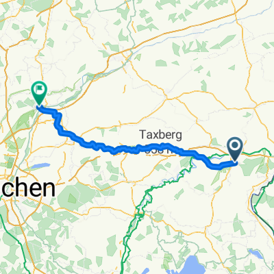
Overview
About this route
- -:--
- Duration
- 39.2 km
- Distance
- 90 m
- Ascent
- 57 m
- Descent
- ---
- Avg. speed
- ---
- Max. altitude
Part of
2020_OB_NB_OÖ
8 stages
Route quality
Waytypes & surfaces along the route
Waytypes
Road
11.8 km
(30 %)
Quiet road
7.4 km
(19 %)
Surfaces
Paved
30.2 km
(77 %)
Unpaved
5.7 km
(14 %)
Asphalt
28.9 km
(74 %)
Gravel
2.8 km
(7 %)
Continue with Bikemap
Use, edit, or download this cycling route
You would like to ride T7_Vom Inn zum Isental or customize it for your own trip? Here is what you can do with this Bikemap route:
Free features
- Save this route as favorite or in collections
- Copy & plan your own version of this route
- Sync your route with Garmin or Wahoo
Premium features
Free trial for 3 days, or one-time payment. More about Bikemap Premium.
- Navigate this route on iOS & Android
- Export a GPX / KML file of this route
- Create your custom printout (try it for free)
- Download this route for offline navigation
Discover more Premium features.
Get Bikemap PremiumFrom our community
Other popular routes starting in Altötting
- Ausweichroute des 1.Altöttinger Radltags (Wetterbedingt)
- Distance
- 31.1 km
- Ascent
- 149 m
- Descent
- 150 m
- Location
- Altötting, Bavaria, Germany
- Teil_7_Altötting-Wörth_an_der_Isar
- Distance
- 69.4 km
- Ascent
- 324 m
- Descent
- 359 m
- Location
- Altötting, Bavaria, Germany
- 05 Rundtour Flössinger See
- Distance
- 50.6 km
- Ascent
- 184 m
- Descent
- 184 m
- Location
- Altötting, Bavaria, Germany
- Altötting - Waldkraiburg - Altötting
- Distance
- 60.9 km
- Ascent
- 201 m
- Descent
- 202 m
- Location
- Altötting, Bavaria, Germany
- Altöttinger Radltag 2019 (Kinderrunde am Inn)
- Distance
- 11.1 km
- Ascent
- 41 m
- Descent
- 39 m
- Location
- Altötting, Bavaria, Germany
- Altötting-Winhöring-Reischach-Perach-Altötting
- Distance
- 36.9 km
- Ascent
- 268 m
- Descent
- 269 m
- Location
- Altötting, Bavaria, Germany
- Altötting-Burghausen-Marktl-Neuötting-Altötting
- Distance
- 43.2 km
- Ascent
- 144 m
- Descent
- 144 m
- Location
- Altötting, Bavaria, Germany
- Route nach Vorschlägen
- Distance
- 34.6 km
- Ascent
- 137 m
- Descent
- 137 m
- Location
- Altötting, Bavaria, Germany
Open it in the app