

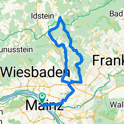
Mz-Kastel - Feldberg - Mz-Kastel
A cycling route starting in Mainz, Rhineland-Palatinate, Germany.
Overview
About this route
Mainz-Kastel (Business area Petersweg, Fort Biehler, Erbenheim, Igstadt, Kloppenheim, Hockenheimer Mühle, Auringen, Naurod, Niedernhausen, Oberjosbach, Ehlhalten, Schlossborn, B8, L3025, Red Cross, Feldbergturm, Sandplacken, Kanonenstraße, Hohemark, Oberursel -Borkenberg, -Stierstädter Heide, Kronberg, Opel Zoo, Königstein Roundabout, Schneidhain, Fischbach, Eppstein, Lorsbach, Hofheim, Marxheim, Diedenbergen, Wallau, Delkenheim, Mechthildshausen, Airbase, Fort Biehler, Mainz-Kastel (Business area Petersweg)
- -:--
- Duration
- 94.6 km
- Distance
- 1,496 m
- Ascent
- 1,432 m
- Descent
- ---
- Avg. speed
- 879 m
- Max. altitude

Route quality
Waytypes & surfaces along the route
Waytypes
Quiet road
16.1 km
(17 %)
Road
14.2 km
(15 %)
Surfaces
Paved
72.8 km
(77 %)
Unpaved
7.6 km
(8 %)
Asphalt
63.4 km
(67 %)
Concrete
5.7 km
(6 %)
Continue with Bikemap
Use, edit, or download this cycling route
You would like to ride Mz-Kastel - Feldberg - Mz-Kastel or customize it for your own trip? Here is what you can do with this Bikemap route:
Free features
- Save this route as favorite or in collections
- Copy & plan your own version of this route
- Split it into stages to create a multi-day tour
- Sync your route with Garmin or Wahoo
Premium features
Free trial for 3 days, or one-time payment. More about Bikemap Premium.
- Navigate this route on iOS & Android
- Export a GPX / KML file of this route
- Create your custom printout (try it for free)
- Download this route for offline navigation
Discover more Premium features.
Get Bikemap PremiumFrom our community
Other popular routes starting in Mainz
 Mainz Ingelheim-Nord Oestrich-winkel
- Distance
- 46.8 km
- Ascent
- 62 m
- Descent
- 60 m
- Location
- Mainz, Rhineland-Palatinate, Germany
 Kleine Rhein-Main Runde
- Distance
- 16.3 km
- Ascent
- 31 m
- Descent
- 31 m
- Location
- Mainz, Rhineland-Palatinate, Germany
 20190824 Schoppingroute
- Distance
- 15.7 km
- Ascent
- 72 m
- Descent
- 71 m
- Location
- Mainz, Rhineland-Palatinate, Germany
 2015_07 - Mainz Gonsenheim - Budenheim - Mombach - Mainz
- Distance
- 14.9 km
- Ascent
- 71 m
- Descent
- 75 m
- Location
- Mainz, Rhineland-Palatinate, Germany
 Kleiner Rundweg zwischen MzKastel und Wicker
- Distance
- 23.7 km
- Ascent
- 104 m
- Descent
- 87 m
- Location
- Mainz, Rhineland-Palatinate, Germany
 Mainz-Lorsbachtal-Heftrich-Niedernhausen-Mainz
- Distance
- 82.4 km
- Ascent
- 719 m
- Descent
- 720 m
- Location
- Mainz, Rhineland-Palatinate, Germany
 31_Mainz – Heidesheim – Ingelheim – Gonsenheim – Mainz
- Distance
- 40.5 km
- Ascent
- 227 m
- Descent
- 213 m
- Location
- Mainz, Rhineland-Palatinate, Germany
 Runde über Lörzweiler
- Distance
- 34.5 km
- Ascent
- 241 m
- Descent
- 238 m
- Location
- Mainz, Rhineland-Palatinate, Germany
Open it in the app