

Puszcza Bukowa, Kołbacz, Jezioro Miedwie i Stargard..
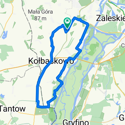
A cycling route starting in Przecław, West Pomeranian Voivodeship, Poland.
Overview
About this route
- -:--
- Duration
- 104.2 km
- Distance
- 665 m
- Ascent
- 664 m
- Descent
- ---
- Avg. speed
- ---
- Max. altitude

Route quality
Waytypes & surfaces along the route
Waytypes
Track
21.9 km
(21 %)
Quiet road
19.8 km
(19 %)
Surfaces
Paved
62.5 km
(60 %)
Unpaved
15.6 km
(15 %)
Asphalt
59.4 km
(57 %)
Ground
11.5 km
(11 %)
Continue with Bikemap
Use, edit, or download this cycling route
You would like to ride Puszcza Bukowa, Kołbacz, Jezioro Miedwie i Stargard.. or customize it for your own trip? Here is what you can do with this Bikemap route:
Free features
- Save this route as favorite or in collections
- Copy & plan your own version of this route
- Split it into stages to create a multi-day tour
- Sync your route with Garmin or Wahoo
Premium features
Free trial for 3 days, or one-time payment. More about Bikemap Premium.
- Navigate this route on iOS & Android
- Export a GPX / KML file of this route
- Create your custom printout (try it for free)
- Download this route for offline navigation
Discover more Premium features.
Get Bikemap PremiumFrom our community
Other popular routes starting in Przecław
 Rajd Artylerzystów 2015
- Distance
- 21.9 km
- Ascent
- 155 m
- Descent
- 155 m
- Location
- Przecław, West Pomeranian Voivodeship, Poland
 Prof Władysława Grabskiego 6, Szczecin do Południowa 28, Szczecin
- Distance
- 35.3 km
- Ascent
- 279 m
- Descent
- 290 m
- Location
- Przecław, West Pomeranian Voivodeship, Poland
 Eugeniusza Kwiatkowskiego 1A, Szczecin do Cukrowa 18, Szczecin
- Distance
- 46 km
- Ascent
- 329 m
- Descent
- 328 m
- Location
- Przecław, West Pomeranian Voivodeship, Poland
 Szlak Orła Bielika wiosennie
- Distance
- 39 km
- Ascent
- 178 m
- Descent
- 178 m
- Location
- Przecław, West Pomeranian Voivodeship, Poland
 Puszcza Bukowa Solna 6 do Solna 2–32, Szczecin Podjuchy
- Distance
- 14.8 km
- Ascent
- 428 m
- Descent
- 431 m
- Location
- Przecław, West Pomeranian Voivodeship, Poland
 Szczecin Podjuchy - Gryfino
- Distance
- 27.5 km
- Ascent
- 241 m
- Descent
- 221 m
- Location
- Przecław, West Pomeranian Voivodeship, Poland
 Serwis
- Distance
- 23.7 km
- Ascent
- 75 m
- Descent
- 75 m
- Location
- Przecław, West Pomeranian Voivodeship, Poland
 Szczecin - Buk - Peenemunde - Swinoujście 2015
- Distance
- 201.5 km
- Ascent
- 226 m
- Descent
- 245 m
- Location
- Przecław, West Pomeranian Voivodeship, Poland
Open it in the app