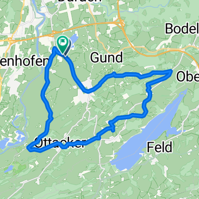
Um den Rottachsee über Berg und Tal
A cycling route starting in Sulzberg, Bavaria, Germany.
Overview
About this route
There is also a nice circular path that follows the lake's course directly, but the ride over the heights is - especially with good visibility - also very appealing. Especially if you like mountains.
- -:--
- Duration
- 30.8 km
- Distance
- 524 m
- Ascent
- 524 m
- Descent
- ---
- Avg. speed
- ---
- Max. altitude
Continue with Bikemap
Use, edit, or download this cycling route
You would like to ride Um den Rottachsee über Berg und Tal or customize it for your own trip? Here is what you can do with this Bikemap route:
Free features
- Save this route as favorite or in collections
- Copy & plan your own version of this route
- Sync your route with Garmin or Wahoo
Premium features
Free trial for 3 days, or one-time payment. More about Bikemap Premium.
- Navigate this route on iOS & Android
- Export a GPX / KML file of this route
- Create your custom printout (try it for free)
- Download this route for offline navigation
Discover more Premium features.
Get Bikemap PremiumFrom our community
Other popular routes starting in Sulzberg
- Camping Dopfer/Sulzberger See - Füssen
- Distance
- 43.2 km
- Ascent
- 459 m
- Descent
- 360 m
- Location
- Sulzberg, Bavaria, Germany
- Rottach-Grüntensee-Rundtour
- Distance
- 51.7 km
- Ascent
- 561 m
- Descent
- 561 m
- Location
- Sulzberg, Bavaria, Germany
- Um den Rottachsee über Berg und Tal
- Distance
- 30.8 km
- Ascent
- 524 m
- Descent
- 524 m
- Location
- Sulzberg, Bavaria, Germany
- Riedis
- Distance
- 4.7 km
- Ascent
- 94 m
- Descent
- 86 m
- Location
- Sulzberg, Bavaria, Germany
- rund Öschlesee-Fuß
- Distance
- 3.5 km
- Ascent
- 8 m
- Descent
- 9 m
- Location
- Sulzberg, Bavaria, Germany
- Sulzberg-Römerhaus-Hasenried-Aleuthe-Sulzberg
- Distance
- 6.1 km
- Ascent
- 209 m
- Descent
- 208 m
- Location
- Sulzberg, Bavaria, Germany
- Sulzberger See-Elleghöhe-Königssträßchen-Niedersonthofen-Hellengerst-Martinszell
- Distance
- 87.2 km
- Ascent
- 1,052 m
- Descent
- 1,052 m
- Location
- Sulzberg, Bavaria, Germany
- Tannheimer Tal - Oberjoch
- Distance
- 106.6 km
- Ascent
- 854 m
- Descent
- 852 m
- Location
- Sulzberg, Bavaria, Germany
Open it in the app