

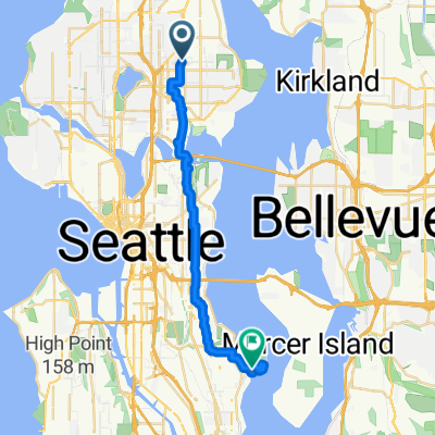
Burke-Gilman Trail, Seattle to 3850 Montlake Blvd NE, Seattle
A cycling route starting in Inglewood-Finn Hill, Washington, United States of America.
Overview
About this route
- 30 min
- Duration
- 10.9 km
- Distance
- 0 m
- Ascent
- 4 m
- Descent
- 21.5 km/h
- Avg. speed
- ---
- Max. altitude

Route quality
Waytypes & surfaces along the route
Waytypes
Cycleway
9.1 km
(84 %)
Pedestrian area
0.8 km
(7 %)
Surfaces
Paved
10.6 km
(97 %)
Unpaved
0 km
(<1 %)
Asphalt
7.1 km
(65 %)
Paved (undefined)
3.3 km
(30 %)
Continue with Bikemap
Use, edit, or download this cycling route
You would like to ride Burke-Gilman Trail, Seattle to 3850 Montlake Blvd NE, Seattle or customize it for your own trip? Here is what you can do with this Bikemap route:
Free features
- Save this route as favorite or in collections
- Copy & plan your own version of this route
- Sync your route with Garmin or Wahoo
Premium features
Free trial for 3 days, or one-time payment. More about Bikemap Premium.
- Navigate this route on iOS & Android
- Export a GPX / KML file of this route
- Create your custom printout (try it for free)
- Download this route for offline navigation
Discover more Premium features.
Get Bikemap PremiumFrom our community
Other popular routes starting in Inglewood-Finn Hill
 Juanita Hill
- Distance
- 4.6 km
- Ascent
- 176 m
- Descent
- 33 m
- Location
- Inglewood-Finn Hill, Washington, United States of America
 Lake Loop
- Distance
- 40.8 km
- Ascent
- 421 m
- Descent
- 420 m
- Location
- Inglewood-Finn Hill, Washington, United States of America
 20th Ave NE and NE 70th St to Nathan Hale, route 1
- Distance
- 3.9 km
- Ascent
- 18 m
- Descent
- 73 m
- Location
- Inglewood-Finn Hill, Washington, United States of America
 Ravenna Ave NE, Seattle to Seward Park Rd, Seattle
- Distance
- 22.7 km
- Ascent
- 495 m
- Descent
- 567 m
- Location
- Inglewood-Finn Hill, Washington, United States of America
 Lake Washington Loop
- Distance
- 79.4 km
- Ascent
- 393 m
- Descent
- 393 m
- Location
- Inglewood-Finn Hill, Washington, United States of America
 Half Lake Washington
- Distance
- 76.6 km
- Ascent
- 613 m
- Descent
- 604 m
- Location
- Inglewood-Finn Hill, Washington, United States of America
 Tour of Lake Sammamish
- Distance
- 63.7 km
- Ascent
- 334 m
- Descent
- 326 m
- Location
- Inglewood-Finn Hill, Washington, United States of America
 Route to 2518 34th Avenue West, Seattle, WA 98199
- Distance
- 12.5 km
- Ascent
- 146 m
- Descent
- 170 m
- Location
- Inglewood-Finn Hill, Washington, United States of America
Open it in the app