

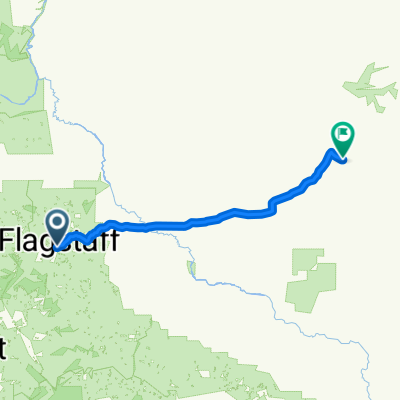
Flagstaff to Munds Park
A cycling route starting in Flagstaff, Arizona, United States.
Overview
About this route
From shelter to home!
89A is paved and fun to ride. Old Munds Highway is primitive and is worthwhile for its views.
When coming close to Mormon Lake, the route becomes strictly ideal for mountain biking; including many steep hills, boulders, and plenty of rowdy campers.
- -:--
- Duration
- 41 km
- Distance
- 238 m
- Ascent
- 311 m
- Descent
- ---
- Avg. speed
- ---
- Max. altitude

Continue with Bikemap
Use, edit, or download this cycling route
You would like to ride Flagstaff to Munds Park or customize it for your own trip? Here is what you can do with this Bikemap route:
Free features
- Save this route as favorite or in collections
- Copy & plan your own version of this route
- Sync your route with Garmin or Wahoo
Premium features
Free trial for 3 days, or one-time payment. More about Bikemap Premium.
- Navigate this route on iOS & Android
- Export a GPX / KML file of this route
- Create your custom printout (try it for free)
- Download this route for offline navigation
Discover more Premium features.
Get Bikemap PremiumFrom our community
Other popular routes starting in Flagstaff
 Day 26
- Distance
- 149.4 km
- Ascent
- 1,430 m
- Descent
- 1,912 m
- Location
- Flagstaff, Arizona, United States
 7. Tag C2C Flagstaff - Holbrook, AZ
- Distance
- 145.3 km
- Ascent
- 141 m
- Descent
- 699 m
- Location
- Flagstaff, Arizona, United States
 day 11 - Winslow AZ
- Distance
- 99.6 km
- Ascent
- 72 m
- Descent
- 699 m
- Location
- Flagstaff, Arizona, United States
 Flagstaff Lake Mormon
- Distance
- 87.1 km
- Ascent
- 377 m
- Descent
- 355 m
- Location
- Flagstaff, Arizona, United States
 Flagstaff to Grand Canyon Loop
- Distance
- 296.7 km
- Ascent
- 1,906 m
- Descent
- 1,891 m
- Location
- Flagstaff, Arizona, United States
 Flagstaff to Page Lake Powel
- Distance
- 332.1 km
- Ascent
- 1,455 m
- Descent
- 2,229 m
- Location
- Flagstaff, Arizona, United States
 NAU loop
- Distance
- 16.7 km
- Ascent
- 153 m
- Descent
- 152 m
- Location
- Flagstaff, Arizona, United States
 357 W Forest Meadows St, Flagstaff to US-191, Ganado
- Distance
- 230.2 km
- Ascent
- 990 m
- Descent
- 1,140 m
- Location
- Flagstaff, Arizona, United States
Open it in the app