
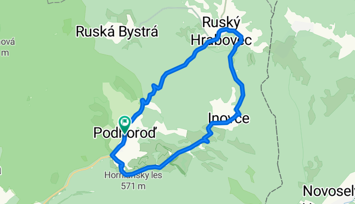
Podhoroď-Beňatina-Inovce-Ruský Hrabovec-Podhoroď
A cycling route starting in Sobrance, Košice Region, Slovakia.
Overview
About this route
- -:--
- Duration
- 19.7 km
- Distance
- 407 m
- Ascent
- 407 m
- Descent
- ---
- Avg. speed
- ---
- Max. altitude

Route quality
Waytypes & surfaces along the route
Waytypes
Road
6.7 km
(34 %)
Quiet road
5.1 km
(26 %)
Undefined
7.9 km
(40 %)
Surfaces
Paved
3.8 km
(19 %)
Asphalt
3.8 km
(19 %)
Undefined
16 km
(81 %)
Route highlights
Points of interest along the route
Point of interest after 5.9 km
Beňatina lom
Point of interest after 19.1 km
Hrad Tibava
Continue with Bikemap
Use, edit, or download this cycling route
You would like to ride Podhoroď-Beňatina-Inovce-Ruský Hrabovec-Podhoroď or customize it for your own trip? Here is what you can do with this Bikemap route:
Free features
- Save this route as favorite or in collections
- Copy & plan your own version of this route
- Sync your route with Garmin or Wahoo
Premium features
Free trial for 3 days, or one-time payment. More about Bikemap Premium.
- Navigate this route on iOS & Android
- Export a GPX / KML file of this route
- Create your custom printout (try it for free)
- Download this route for offline navigation
Discover more Premium features.
Get Bikemap PremiumFrom our community
Other popular routes starting in Sobrance
 Slovensko1
- Distance
- 366.7 km
- Ascent
- 2,063 m
- Descent
- 1,671 m
- Location
- Sobrance, Košice Region, Slovakia
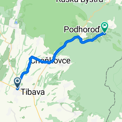 Sobrance- Baškovce- Choňkovce- Beňatina
- Distance
- 18.3 km
- Ascent
- 369 m
- Descent
- 25 m
- Location
- Sobrance, Košice Region, Slovakia
 Sobrance- Bl.Polianka- Senian. rybníky (pozorovateľne vtáctva)
- Distance
- 24.7 km
- Ascent
- 4 m
- Descent
- 20 m
- Location
- Sobrance, Košice Region, Slovakia
 Podhoroď-Beňatina-Inovce-Ruský Hrabovec-Podhoroď
- Distance
- 19.7 km
- Ascent
- 407 m
- Descent
- 407 m
- Location
- Sobrance, Košice Region, Slovakia
 Sobrance- Choňkovce- Beňatina- Inovce
- Distance
- 20.8 km
- Ascent
- 454 m
- Descent
- 85 m
- Location
- Sobrance, Košice Region, Slovakia
 Remetské Hámre - Stakčín
- Distance
- 42.8 km
- Ascent
- 587 m
- Descent
- 625 m
- Location
- Sobrance, Košice Region, Slovakia
 Vihorlát Keleti oldal
- Distance
- 89.3 km
- Ascent
- 907 m
- Descent
- 906 m
- Location
- Sobrance, Košice Region, Slovakia
 Po lesných cestách I
- Distance
- 69.3 km
- Ascent
- 987 m
- Descent
- 985 m
- Location
- Sobrance, Košice Region, Slovakia
Open it in the app