

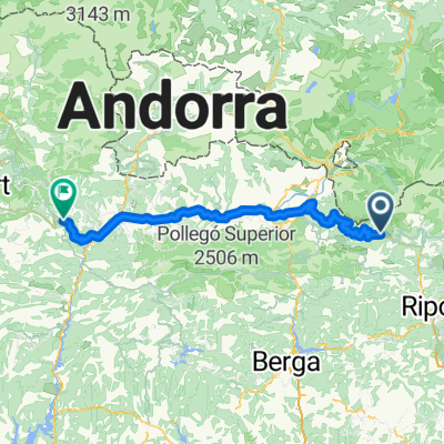
Tour Catalogne _ Figueres - Vall de Núria
A cycling route starting in Planoles, Catalonia, Spain.
Overview
About this route
- -:--
- Duration
- 163.3 km
- Distance
- 1,348 m
- Ascent
- 3,375 m
- Descent
- ---
- Avg. speed
- ---
- Max. altitude

Route quality
Waytypes & surfaces along the route
Waytypes
Track
27.8 km
(17 %)
Road
18 km
(11 %)
Surfaces
Paved
96.4 km
(59 %)
Unpaved
9.8 km
(6 %)
Asphalt
84.9 km
(52 %)
Paved (undefined)
11.4 km
(7 %)
Route highlights
Points of interest along the route
Point of interest after 2.3 km
Vall de Núria Station 2000m
Point of interest after 2.3 km
Masella Station
Point of interest after 2.3 km
Estany Gento 1900m
Point of interest after 2.3 km
Baqueira Beret Station 1800m
Point of interest after 2.3 km
Boí Taüll Resort Station
Point of interest after 2.3 km
La Molina Station
Point of interest after 2.3 km
Collado de la Creu de Perves
Point of interest after 2.3 km
Coret Oelhacrestada
Point of interest after 2.3 km
Collado del Cantó
Point of interest after 53.4 km
Collada del Burgarès
Point of interest after 78.1 km
Coll d'Ares
Point of interest after 84.5 km
Coll de la Seille
Point of interest after 140 km
Coll de Portus
Continue with Bikemap
Use, edit, or download this cycling route
You would like to ride Tour Catalogne _ Figueres - Vall de Núria or customize it for your own trip? Here is what you can do with this Bikemap route:
Free features
- Save this route as favorite or in collections
- Copy & plan your own version of this route
- Split it into stages to create a multi-day tour
- Sync your route with Garmin or Wahoo
Premium features
Free trial for 3 days, or one-time payment. More about Bikemap Premium.
- Navigate this route on iOS & Android
- Export a GPX / KML file of this route
- Create your custom printout (try it for free)
- Download this route for offline navigation
Discover more Premium features.
Get Bikemap PremiumFrom our community
Other popular routes starting in Planoles
 Tour Catalogne _ Figueres - Vall de Núria
- Distance
- 163.3 km
- Ascent
- 1,348 m
- Descent
- 3,375 m
- Location
- Planoles, Catalonia, Spain
 Испания 2
- Distance
- 866.1 km
- Ascent
- 2,330 m
- Descent
- 4,378 m
- Location
- Planoles, Catalonia, Spain
 Refugi a Sant quirze de besora
- Distance
- 67.9 km
- Ascent
- 765 m
- Descent
- 1,420 m
- Location
- Planoles, Catalonia, Spain
 planoles-nev15km
- Distance
- 14.7 km
- Ascent
- 590 m
- Descent
- 591 m
- Location
- Planoles, Catalonia, Spain
 Planoles - La Seu d'Urgell
- Distance
- 96.6 km
- Ascent
- 936 m
- Descent
- 1,031 m
- Location
- Planoles, Catalonia, Spain
 De Carretera de Montgrony, Gombrèn a Carretera de Montgrony, Gombrèn
- Distance
- 12.9 km
- Ascent
- 870 m
- Descent
- 836 m
- Location
- Planoles, Catalonia, Spain
 Planoles - Molins
- Distance
- 155.4 km
- Ascent
- 2,145 m
- Descent
- 3,298 m
- Location
- Planoles, Catalonia, Spain
 PLANOLES - RIERA MERLES - STQ.
- Distance
- 201.3 km
- Ascent
- 4,446 m
- Descent
- 5,455 m
- Location
- Planoles, Catalonia, Spain
Open it in the app