

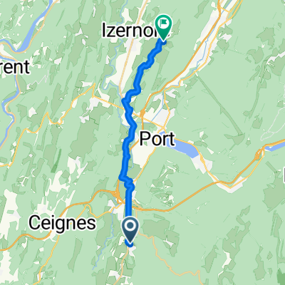
De 30 Route de la Combe du Val, Condamine à Rue Saint-Romain, Izernore
A cycling route starting in Saint-Martin-du-Frêne, Auvergne-Rhône-Alpes, France.
Overview
About this route
- 58 min
- Duration
- 15.3 km
- Distance
- 172 m
- Ascent
- 166 m
- Descent
- 15.7 km/h
- Avg. speed
- ---
- Max. altitude

Route quality
Waytypes & surfaces along the route
Waytypes
Quiet road
8.3 km
(54 %)
Road
4.4 km
(29 %)
Undefined
2.6 km
(17 %)
Surfaces
Paved
1.4 km
(9 %)
Asphalt
1.4 km
(9 %)
Undefined
13.9 km
(91 %)
Continue with Bikemap
Use, edit, or download this cycling route
You would like to ride De 30 Route de la Combe du Val, Condamine à Rue Saint-Romain, Izernore or customize it for your own trip? Here is what you can do with this Bikemap route:
Free features
- Save this route as favorite or in collections
- Copy & plan your own version of this route
- Sync your route with Garmin or Wahoo
Premium features
Free trial for 3 days, or one-time payment. More about Bikemap Premium.
- Navigate this route on iOS & Android
- Export a GPX / KML file of this route
- Create your custom printout (try it for free)
- Download this route for offline navigation
Discover more Premium features.
Get Bikemap PremiumFrom our community
Other popular routes starting in Saint-Martin-du-Frêne
 De 30 Route de la Combe du Val, Condamine à Rue Saint-Romain, Izernore
- Distance
- 15.3 km
- Ascent
- 172 m
- Descent
- 166 m
- Location
- Saint-Martin-du-Frêne, Auvergne-Rhône-Alpes, France
 Chevillard - Gex, 5h (plutôt 8, gros dénivelé)
- Distance
- 80 km
- Ascent
- 853 m
- Descent
- 1,105 m
- Location
- Saint-Martin-du-Frêne, Auvergne-Rhône-Alpes, France
 Maillat - Monts de l'Ain
- Distance
- 83.9 km
- Ascent
- 1,488 m
- Descent
- 1,487 m
- Location
- Saint-Martin-du-Frêne, Auvergne-Rhône-Alpes, France
 De D1084, Maillat à 11 Rue des Millières, Saint-André-de-Corcy
- Distance
- 57.2 km
- Ascent
- 226 m
- Descent
- 511 m
- Location
- Saint-Martin-du-Frêne, Auvergne-Rhône-Alpes, France
 Chevillard - Divonne (1 j)
- Distance
- 82.2 km
- Ascent
- 745 m
- Descent
- 1,067 m
- Location
- Saint-Martin-du-Frêne, Auvergne-Rhône-Alpes, France
 col de pisseloup
- Distance
- 25.7 km
- Ascent
- 549 m
- Descent
- 549 m
- Location
- Saint-Martin-du-Frêne, Auvergne-Rhône-Alpes, France
 De 26 Grande Rue, Saint-Martin-du-Fresne à 2–108 Place de la Mairie, Champdor
- Distance
- 19.1 km
- Ascent
- 497 m
- Descent
- 185 m
- Location
- Saint-Martin-du-Frêne, Auvergne-Rhône-Alpes, France
 De 82 Route des Grands Moulins, Maillat à 100 Place de la Mairie, Champdor
- Distance
- 17.2 km
- Ascent
- 511 m
- Descent
- 182 m
- Location
- Saint-Martin-du-Frêne, Auvergne-Rhône-Alpes, France
Open it in the app