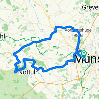
MS-Waltrop-MS
A cycling route starting in Münster, North Rhine-Westphalia, Germany.
Overview
About this route
- -:--
- Duration
- 120.6 km
- Distance
- 322 m
- Ascent
- 332 m
- Descent
- ---
- Avg. speed
- 105 m
- Avg. speed
Route quality
Waytypes & surfaces along the route
Waytypes
Road
39.7 km
(33 %)
Path
31.2 km
(26 %)
Surfaces
Paved
112.6 km
(93 %)
Unpaved
0.4 km
(<1 %)
Asphalt
102.4 km
(85 %)
Paving stones
9.7 km
(8 %)
Continue with Bikemap
Use, edit, or download this cycling route
You would like to ride MS-Waltrop-MS or customize it for your own trip? Here is what you can do with this Bikemap route:
Free features
- Save this route as favorite or in collections
- Copy & plan your own version of this route
- Sync your route with Garmin or Wahoo
Premium features
Free trial for 3 days, or one-time payment. More about Bikemap Premium.
- Navigate this route on iOS & Android
- Export a GPX / KML file of this route
- Create your custom printout (try it for free)
- Download this route for offline navigation
Discover more Premium features.
Get Bikemap PremiumFrom our community
Other popular routes starting in Münster
- Mittlere Trainingsrunde im Osten Münsters
- Distance
- 56.3 km
- Ascent
- 61 m
- Descent
- 67 m
- Location
- Münster, North Rhine-Westphalia, Germany
- Giro 2011 - 110 km Strecke
- Distance
- 111.7 km
- Ascent
- 238 m
- Descent
- 235 m
- Location
- Münster, North Rhine-Westphalia, Germany
- Kurze Münsterlandrunde
- Distance
- 38.7 km
- Ascent
- 109 m
- Descent
- 109 m
- Location
- Münster, North Rhine-Westphalia, Germany
- MS-Rieselfelder-Telgte-MS
- Distance
- 52 km
- Ascent
- 99 m
- Descent
- 99 m
- Location
- Münster, North Rhine-Westphalia, Germany
- Münster - Telgte - Münster
- Distance
- 39.6 km
- Ascent
- 43 m
- Descent
- 44 m
- Location
- Münster, North Rhine-Westphalia, Germany
- Campingplatz - Emsauen- u. Kanal-Tour
- Distance
- 53.2 km
- Ascent
- 182 m
- Descent
- 179 m
- Location
- Münster, North Rhine-Westphalia, Germany
- MS 01
- Distance
- 35.9 km
- Ascent
- 48 m
- Descent
- 46 m
- Location
- Münster, North Rhine-Westphalia, Germany
- Hohe Ward Rundweg
- Distance
- 36.9 km
- Ascent
- 49 m
- Descent
- 48 m
- Location
- Münster, North Rhine-Westphalia, Germany
Open it in the app