

BRT2019-Fr: Durch den Gemüsegarten Deutschlands - RTF des BRT2019-Fr - 48 km Strecke
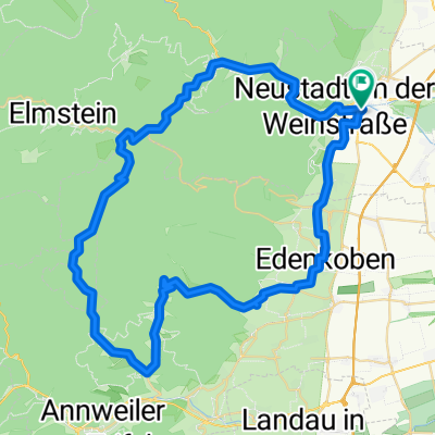
A cycling route starting in Neustadt an der Weinstraße, Rhineland-Palatinate, Germany.
Overview
About this route
BRT2019-Fr: Through the vegetable garden of Germany - 48 km route
RTF of BRT2019-Fr
All further details about this route -> click here
- -:--
- Duration
- 48.7 km
- Distance
- 645 m
- Ascent
- 644 m
- Descent
- ---
- Avg. speed
- 157 m
- Max. altitude

Route quality
Waytypes & surfaces along the route
Waytypes
Track
14.1 km
(29 %)
Quiet road
7.3 km
(15 %)
Surfaces
Paved
42.4 km
(87 %)
Unpaved
0.5 km
(1 %)
Asphalt
33.6 km
(69 %)
Paved (undefined)
7.8 km
(16 %)
Route highlights
Points of interest along the route
Drinking water after 23.3 km
Kontrolle
Continue with Bikemap
Use, edit, or download this cycling route
You would like to ride BRT2019-Fr: Durch den Gemüsegarten Deutschlands - RTF des BRT2019-Fr - 48 km Strecke or customize it for your own trip? Here is what you can do with this Bikemap route:
Free features
- Save this route as favorite or in collections
- Copy & plan your own version of this route
- Sync your route with Garmin or Wahoo
Premium features
Free trial for 3 days, or one-time payment. More about Bikemap Premium.
- Navigate this route on iOS & Android
- Export a GPX / KML file of this route
- Create your custom printout (try it for free)
- Download this route for offline navigation
Discover more Premium features.
Get Bikemap PremiumFrom our community
Other popular routes starting in Neustadt an der Weinstraße
 Kalmit-HohenLog Tour
- Distance
- 47.2 km
- Ascent
- 1,350 m
- Descent
- 1,350 m
- Location
- Neustadt an der Weinstraße, Rhineland-Palatinate, Germany
 Mußbach-Weinbiet-Totenkopfhütte-Mußbach
- Distance
- 44.8 km
- Ascent
- 873 m
- Descent
- 873 m
- Location
- Neustadt an der Weinstraße, Rhineland-Palatinate, Germany
 BRT2019-Fr: Durch den Gemüsegarten Deutschlands - RTF des BRT2019-Fr - 48 km Strecke
- Distance
- 48.7 km
- Ascent
- 645 m
- Descent
- 644 m
- Location
- Neustadt an der Weinstraße, Rhineland-Palatinate, Germany
 Deutschen Weinstraße Tag2
- Distance
- 52.3 km
- Ascent
- 238 m
- Descent
- 261 m
- Location
- Neustadt an der Weinstraße, Rhineland-Palatinate, Germany
 BRT2019-So Entwurf 70km
- Distance
- 62.8 km
- Ascent
- 702 m
- Descent
- 701 m
- Location
- Neustadt an der Weinstraße, Rhineland-Palatinate, Germany
 Große Pfälzerwald Runde
- Distance
- 141.3 km
- Ascent
- 796 m
- Descent
- 798 m
- Location
- Neustadt an der Weinstraße, Rhineland-Palatinate, Germany
 Weinbiet über Haardt
- Distance
- 11.6 km
- Ascent
- 424 m
- Descent
- 352 m
- Location
- Neustadt an der Weinstraße, Rhineland-Palatinate, Germany
 Neustadt - Kalmitrunde
- Distance
- 30.6 km
- Ascent
- 836 m
- Descent
- 839 m
- Location
- Neustadt an der Weinstraße, Rhineland-Palatinate, Germany
Open it in the app