

30. Heidenauer RTF 17.09.2011 - 120 km
A cycling route starting in Heidenau, Saxony, Germany.
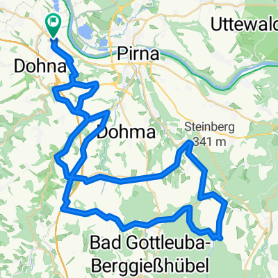
Overview
About this route
17.09.2011 Start: 09-10.30 Uhr
Pestalozzi-Gymnasium Heidenau
KP Stolpen in Stolpen-Zscheppa (P vom Baumarkt Häntzschel&), KP Cunnersdorf am/hinter dem Bad, danach ca. 6 km durch Landesforst nach Rosenthal, KP Berggießhübel auf Bad-Parkplatz
6 Anstiege: in Cunnersdorf, aus dem Sebnitztal nach Lichtenhain, aus Krippengrund hinauf, im Forst vom Abzw. Fuchsteich nach Rosenthal, aus dem Bielatal von Rosenthal nach Raum, aus Berggießhübel nach Gersdorf
7 Abfahrten: Polenztal (Bockmühle), von Ulbersdorf ins Sebnitztal, von Altenhain nach Bad Schandau, nach Rosenthal hinein, von Bahra ins Gottleubatal, nach Gersdorf hinein, sowie von Großsedlitz nach Heidenau
9 Täler: Wesenitztal, Polenztal, Sebnitztal, Elbtal, Krippengrund (mit neuer Asphaltdecke), Bielatal, Gottleubatal, Bahratal, Bahretal, Seidewitztal
für sportliche Erwachsene geeignet, Rennrad von Vorteil
- -:--
- Duration
- 119 km
- Distance
- 955 m
- Ascent
- 955 m
- Descent
- ---
- Avg. speed
- ---
- Max. altitude
Route quality
Waytypes & surfaces along the route
Waytypes
Road
52.4 km
(44 %)
Quiet road
13.1 km
(11 %)
Surfaces
Paved
100 km
(84 %)
Unpaved
2.4 km
(2 %)
Asphalt
94 km
(79 %)
Paved (undefined)
4.8 km
(4 %)
Route highlights
Points of interest along the route
Point of interest after 0 km
Start/Ziel Pestalozzi-Gymnasium Heidenau
Point of interest after 4 km
Tourteilung 160, 120 km - 80, 60, 30 km
Point of interest after 34.6 km
KP1 Stolpen
Point of interest after 49.4 km
Tourteilung 160 km - 120 km
Point of interest after 53.4 km
KP2 Ulbersdorf
Point of interest after 79 km
KP3 Cunnersdorf
Point of interest after 93.2 km
Tourteilung 160 km - 120, 80, 60 km
Point of interest after 98.2 km
KP5 Berggießhübel
Point of interest after 99 km
Tourteilung 80 km - 120, 60 km
Continue with Bikemap
Use, edit, or download this cycling route
You would like to ride 30. Heidenauer RTF 17.09.2011 - 120 km or customize it for your own trip? Here is what you can do with this Bikemap route:
Free features
- Save this route as favorite or in collections
- Copy & plan your own version of this route
- Split it into stages to create a multi-day tour
- Sync your route with Garmin or Wahoo
Premium features
Free trial for 3 days, or one-time payment. More about Bikemap Premium.
- Navigate this route on iOS & Android
- Export a GPX / KML file of this route
- Create your custom printout (try it for free)
- Download this route for offline navigation
Discover more Premium features.
Get Bikemap PremiumFrom our community
Other popular routes starting in Heidenau
 30. Heidenauer RTF 17.09.2011 - 150 km - NEU
- Distance
- 145.4 km
- Ascent
- 1,284 m
- Descent
- 1,284 m
- Location
- Heidenau, Saxony, Germany
 Dresden- Bielatal
- Distance
- 62.7 km
- Ascent
- 605 m
- Descent
- 588 m
- Location
- Heidenau, Saxony, Germany
 tourX
tourX- Distance
- 39.6 km
- Ascent
- 517 m
- Descent
- 572 m
- Location
- Heidenau, Saxony, Germany
 30. Heidenauer RTF 17.09.2011 - 80km NEU
- Distance
- 71.1 km
- Ascent
- 886 m
- Descent
- 886 m
- Location
- Heidenau, Saxony, Germany
 30. Heidenauer RTF 17.09.2011 - 120 km - NEU
- Distance
- 121.7 km
- Ascent
- 996 m
- Descent
- 996 m
- Location
- Heidenau, Saxony, Germany
 33. Heidenauer RTF 20.09.2014 - 60km -
- Distance
- 56.2 km
- Ascent
- 655 m
- Descent
- 656 m
- Location
- Heidenau, Saxony, Germany
 LockwitztalWilischLuchau
- Distance
- 48.3 km
- Ascent
- 809 m
- Descent
- 815 m
- Location
- Heidenau, Saxony, Germany
 Schnelle Ausfahrt vom 28.07.17, 18:38
- Distance
- 7.9 km
- Ascent
- 16 m
- Descent
- 16 m
- Location
- Heidenau, Saxony, Germany
Open it in the app