

Sankt Kilian; Vessertal; Schmiedefeld; Schneekopf; Adlersberg
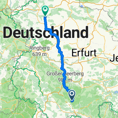
A cycling route starting in Sankt Kilian, Thuringia, Germany.
Overview
About this route
Start parking next to the church in Sankt Kilian; through beautiful Vessertal along the Vesser (moderate climb); Schmiedefeld; Schneekopf; Adlersberg and back.
- -:--
- Duration
- 49.9 km
- Distance
- 857 m
- Ascent
- 857 m
- Descent
- ---
- Avg. speed
- ---
- Max. altitude
Route quality
Waytypes & surfaces along the route
Waytypes
Track
35 km
(70 %)
Quiet road
7.5 km
(15 %)
Surfaces
Paved
13 km
(26 %)
Unpaved
35 km
(70 %)
Gravel
27.5 km
(55 %)
Asphalt
11 km
(22 %)
Continue with Bikemap
Use, edit, or download this cycling route
You would like to ride Sankt Kilian; Vessertal; Schmiedefeld; Schneekopf; Adlersberg or customize it for your own trip? Here is what you can do with this Bikemap route:
Free features
- Save this route as favorite or in collections
- Copy & plan your own version of this route
- Sync your route with Garmin or Wahoo
Premium features
Free trial for 3 days, or one-time payment. More about Bikemap Premium.
- Navigate this route on iOS & Android
- Export a GPX / KML file of this route
- Create your custom printout (try it for free)
- Download this route for offline navigation
Discover more Premium features.
Get Bikemap PremiumFrom our community
Other popular routes starting in Sankt Kilian
 Hirschbach Friedberg Hirschbach
- Distance
- 12.1 km
- Ascent
- 260 m
- Descent
- 260 m
- Location
- Sankt Kilian, Thuringia, Germany
 Hirschbach Atlersberg Breitenbach St.Kilian Hirschbach
- Distance
- 24.3 km
- Ascent
- 456 m
- Descent
- 458 m
- Location
- Sankt Kilian, Thuringia, Germany
 Hirschbach, Erletortalsperre, Suhl Friedberg zurück nach Hirschbach
- Distance
- 16.2 km
- Ascent
- 372 m
- Descent
- 370 m
- Location
- Sankt Kilian, Thuringia, Germany
 Frauenwald - Niederorschel
- Distance
- 125.2 km
- Ascent
- 1,151 m
- Descent
- 1,327 m
- Location
- Sankt Kilian, Thuringia, Germany
 von Hirschbach nach Breitenbach zum Blockhaus
- Distance
- 7.9 km
- Ascent
- 125 m
- Descent
- 84 m
- Location
- Sankt Kilian, Thuringia, Germany
 Vessertal 13,6 KM
- Distance
- 13.6 km
- Ascent
- 335 m
- Descent
- 331 m
- Location
- Sankt Kilian, Thuringia, Germany
 Dillstädt-Simmersberg-Werraquelle-Oelze-Kahlert-Frauenwald-St. Kilian-Suhl-Dillstädt (Teil 3)
- Distance
- 26.5 km
- Ascent
- 370 m
- Descent
- 375 m
- Location
- Sankt Kilian, Thuringia, Germany
 von Hirschbach nach Zella-Mehlis
- Distance
- 19.7 km
- Ascent
- 333 m
- Descent
- 312 m
- Location
- Sankt Kilian, Thuringia, Germany
Open it in the app