

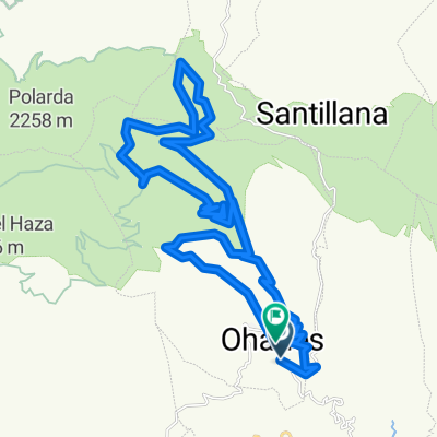
Ohanes - Polarda -veredas - Ohanes
A cycling route starting in Ohanes, Andalusia, Spain.
Overview
About this route
- -:--
- Duration
- 30.2 km
- Distance
- 1,075 m
- Ascent
- 1,075 m
- Descent
- ---
- Avg. speed
- ---
- Max. altitude

Route photos


Route quality
Waytypes & surfaces along the route
Waytypes
Track
24.4 km
(81 %)
Path
3 km
(10 %)
Surfaces
Unpaved
12.4 km
(41 %)
Gravel
12.4 km
(41 %)
Undefined
17.8 km
(59 %)
Route highlights
Points of interest along the route
Point of interest after 14.2 km
posible vereda a derecha
Continue with Bikemap
Use, edit, or download this cycling route
You would like to ride Ohanes - Polarda -veredas - Ohanes or customize it for your own trip? Here is what you can do with this Bikemap route:
Free features
- Save this route as favorite or in collections
- Copy & plan your own version of this route
- Sync your route with Garmin or Wahoo
Premium features
Free trial for 3 days, or one-time payment. More about Bikemap Premium.
- Navigate this route on iOS & Android
- Export a GPX / KML file of this route
- Create your custom printout (try it for free)
- Download this route for offline navigation
Discover more Premium features.
Get Bikemap PremiumFrom our community
Other popular routes starting in Ohanes
 Ohanes - Polarda -veredas - Ohanes
- Distance
- 30.2 km
- Ascent
- 1,075 m
- Descent
- 1,075 m
- Location
- Ohanes, Andalusia, Spain
![Ohanes - Polarda [por Castañar y Majada de las Vacas]](https://media.bikemap.net/routes/374281/staticmaps/in_3c6d6f56-8366-4b6a-8974-1a709de7b9ed_400x400_bikemap-2021-3D-static.png) Ohanes - Polarda [por Castañar y Majada de las Vacas]
Ohanes - Polarda [por Castañar y Majada de las Vacas]- Distance
- 23.8 km
- Ascent
- 1,437 m
- Descent
- 248 m
- Location
- Ohanes, Andalusia, Spain
 Ruta Transnevada E4V: Collado del Espino - Puerto de la Ragua
- Distance
- 35.2 km
- Ascent
- 676 m
- Descent
- 508 m
- Location
- Ohanes, Andalusia, Spain
 II Edición de Migas y Buitre
- Distance
- 60.7 km
- Ascent
- 1,513 m
- Descent
- 1,993 m
- Location
- Ohanes, Andalusia, Spain
 Ohanes dos veredas
- Distance
- 38.6 km
- Ascent
- 1,184 m
- Descent
- 1,179 m
- Location
- Ohanes, Andalusia, Spain
 ohanes - Buitre - Puerto la Ragua - Ohanes
- Distance
- 97.5 km
- Ascent
- 1,873 m
- Descent
- 1,858 m
- Location
- Ohanes, Andalusia, Spain
 Ohanes- Cantarranas-Collado del Espino- Fuente del Cerrajero-Sulayr-Cerro de la Coronela-Cantarranas-Sendero de Ohanes
- Distance
- 37.6 km
- Ascent
- 1,374 m
- Descent
- 1,358 m
- Location
- Ohanes, Andalusia, Spain
 Ohanes-sulayr
- Distance
- 44.9 km
- Ascent
- 1,335 m
- Descent
- 1,335 m
- Location
- Ohanes, Andalusia, Spain
Open it in the app