

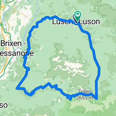
MTB Lüsener Joch
A cycling route starting in Villa, Trentino-Alto Adige, Italy.
Overview
About this route
Steep tour in solitude. Just before Lüsener Joch there is a push section (marathon riders might be able to pedal through it...)! The descent is very varied. Towards Rungg you can repeatedly cross the forest path to increase the trail section...
- -:--
- Duration
- 21.9 km
- Distance
- 1,089 m
- Ascent
- 1,089 m
- Descent
- ---
- Avg. speed
- ---
- Max. altitude

Continue with Bikemap
Use, edit, or download this cycling route
You would like to ride MTB Lüsener Joch or customize it for your own trip? Here is what you can do with this Bikemap route:
Free features
- Save this route as favorite or in collections
- Copy & plan your own version of this route
- Sync your route with Garmin or Wahoo
Premium features
Free trial for 3 days, or one-time payment. More about Bikemap Premium.
- Navigate this route on iOS & Android
- Export a GPX / KML file of this route
- Create your custom printout (try it for free)
- Download this route for offline navigation
Discover more Premium features.
Get Bikemap PremiumFrom our community
Other popular routes starting in Villa
 Runde um die Plose
- Distance
- 44.6 km
- Ascent
- 2,040 m
- Descent
- 1,963 m
- Location
- Villa, Trentino-Alto Adige, Italy
 AlpenX2012_Tag4
- Distance
- 55.6 km
- Ascent
- 2,369 m
- Descent
- 2,736 m
- Location
- Villa, Trentino-Alto Adige, Italy
 2013 Südtirol 1 Lüsen 38 km 900hm
- Distance
- 38.2 km
- Ascent
- 991 m
- Descent
- 1,473 m
- Location
- Villa, Trentino-Alto Adige, Italy
 Plose-Runde
- Distance
- 50.7 km
- Ascent
- 1,403 m
- Descent
- 1,397 m
- Location
- Villa, Trentino-Alto Adige, Italy
 Dorfgasse 2, Lüsen nach Sankt Kilianweg 5, Lüsen
- Distance
- 7.5 km
- Ascent
- 329 m
- Descent
- 274 m
- Location
- Villa, Trentino-Alto Adige, Italy
 Lüsen - Lüsener Alm - Lüsen
- Distance
- 22.2 km
- Ascent
- 1,135 m
- Descent
- 1,135 m
- Location
- Villa, Trentino-Alto Adige, Italy
 Luson
Luson- Distance
- 22.3 km
- Ascent
- 1,021 m
- Descent
- 1,020 m
- Location
- Villa, Trentino-Alto Adige, Italy
 Lüsen nach Andelhütte
- Distance
- 16.5 km
- Ascent
- 973 m
- Descent
- 870 m
- Location
- Villa, Trentino-Alto Adige, Italy
Open it in the app