

Erkundung Oberes Erzgebirge
A cycling route starting in Markersbach, Saxony, Germany.
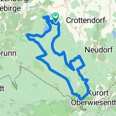
Overview
About this route
Oberbecken
Keilberg
Plessberg
Albertamy
Bergstadt Platten
Johannstadt
Schwarzenberg
Raschau
Markersbach
Unterbecken
- -:--
- Duration
- 81.5 km
- Distance
- 904 m
- Ascent
- 1,156 m
- Descent
- ---
- Avg. speed
- ---
- Max. altitude

Route quality
Waytypes & surfaces along the route
Waytypes
Track
13 km
(16 %)
Quiet road
12.2 km
(15 %)
Surfaces
Paved
58.7 km
(72 %)
Unpaved
6.5 km
(8 %)
Asphalt
57.1 km
(70 %)
Gravel
3.3 km
(4 %)
Continue with Bikemap
Use, edit, or download this cycling route
You would like to ride Erkundung Oberes Erzgebirge or customize it for your own trip? Here is what you can do with this Bikemap route:
Free features
- Save this route as favorite or in collections
- Copy & plan your own version of this route
- Split it into stages to create a multi-day tour
- Sync your route with Garmin or Wahoo
Premium features
Free trial for 3 days, or one-time payment. More about Bikemap Premium.
- Navigate this route on iOS & Android
- Export a GPX / KML file of this route
- Create your custom printout (try it for free)
- Download this route for offline navigation
Discover more Premium features.
Get Bikemap PremiumFrom our community
Other popular routes starting in Markersbach
 Fichtelbergrunde
- Distance
- 46.9 km
- Ascent
- 1,024 m
- Descent
- 1,035 m
- Location
- Markersbach, Saxony, Germany
 Erzgebirgsradrennen Markersbach
- Distance
- 47 km
- Ascent
- 1,023 m
- Descent
- 1,034 m
- Location
- Markersbach, Saxony, Germany
 E2 - Markersbach - 3x Taufichtig und Ziel am Parkplatz Oberbecken Markersbach
- Distance
- 89.6 km
- Ascent
- 1,554 m
- Descent
- 1,368 m
- Location
- Markersbach, Saxony, Germany
 Pumpspeicherkraftwerk Markersbach zum Fichtelberg und zurück
- Distance
- 32.8 km
- Ascent
- 454 m
- Descent
- 454 m
- Location
- Markersbach, Saxony, Germany
 ERZ-Tour 2016 - Markersbach I - Fichtelforest (Kontrolle notwendig wegen Asphalt!)
- Distance
- 39.5 km
- Ascent
- 800 m
- Descent
- 606 m
- Location
- Markersbach, Saxony, Germany
 2.Bergzeitfahren Markersbach / 15.08.2014
- Distance
- 5.2 km
- Ascent
- 362 m
- Descent
- 47 m
- Location
- Markersbach, Saxony, Germany
 Oberbecken und Hundsmarter Skatinģ Schnee
- Distance
- 12.9 km
- Ascent
- 471 m
- Descent
- 465 m
- Location
- Markersbach, Saxony, Germany
 Erzgebirgsradrennen Makersbach
- Distance
- 45.7 km
- Ascent
- 1,058 m
- Descent
- 973 m
- Location
- Markersbach, Saxony, Germany
Open it in the app