
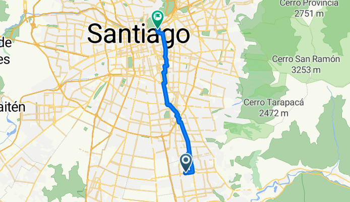
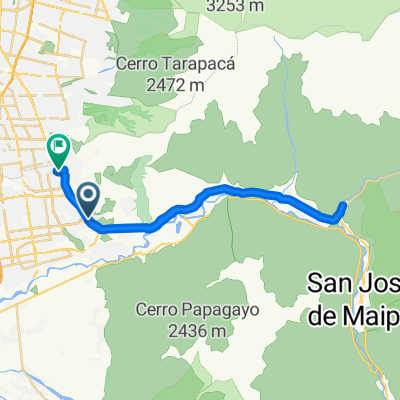
Camino a la Clínica Santa María
A cycling route starting in Puente Alto, Santiago Metropolitan, Chile.
Overview
About this route
- -:--
- Duration
- 21.2 km
- Distance
- 50 m
- Ascent
- 118 m
- Descent
- ---
- Avg. speed
- ---
- Max. altitude

Route quality
Waytypes & surfaces along the route
Waytypes
Cycleway
10 km
(47 %)
Quiet road
4.9 km
(23 %)
Surfaces
Paved
18.9 km
(89 %)
Asphalt
7.4 km
(35 %)
Concrete
5.9 km
(28 %)
Continue with Bikemap
Use, edit, or download this cycling route
You would like to ride Camino a la Clínica Santa María or customize it for your own trip? Here is what you can do with this Bikemap route:
Free features
- Save this route as favorite or in collections
- Copy & plan your own version of this route
- Sync your route with Garmin or Wahoo
Premium features
Free trial for 3 days, or one-time payment. More about Bikemap Premium.
- Navigate this route on iOS & Android
- Export a GPX / KML file of this route
- Create your custom printout (try it for free)
- Download this route for offline navigation
Discover more Premium features.
Get Bikemap PremiumFrom our community
Other popular routes starting in Puente Alto
 Camino a la Clínica Santa María
- Distance
- 21.2 km
- Ascent
- 50 m
- Descent
- 118 m
- Location
- Puente Alto, Santiago Metropolitan, Chile
 vuelta nocturna 1
- Distance
- 4.7 km
- Ascent
- 25 m
- Descent
- 47 m
- Location
- Puente Alto, Santiago Metropolitan, Chile
 Ruta Santa Rita Pirque
- Distance
- 28.9 km
- Ascent
- 48 m
- Descent
- 65 m
- Location
- Puente Alto, Santiago Metropolitan, Chile
 paseo por mi patio
- Distance
- 31.8 km
- Ascent
- 321 m
- Descent
- 323 m
- Location
- Puente Alto, Santiago Metropolitan, Chile
 De Arce interior Oriente, Puente Alto a El Colorado, San José de Maipo
- Distance
- 41.7 km
- Ascent
- 534 m
- Descent
- 523 m
- Location
- Puente Alto, Santiago Metropolitan, Chile
 hagarrando el ritmo
- Distance
- 29.6 km
- Ascent
- 318 m
- Descent
- 313 m
- Location
- Puente Alto, Santiago Metropolitan, Chile
 De Caletera Acceso Sur a Estación El Canelo
- Distance
- 19.6 km
- Ascent
- 68 m
- Descent
- 89 m
- Location
- Puente Alto, Santiago Metropolitan, Chile
 De Salitrera Mapocho a Salitrera Mapocho
- Distance
- 16.9 km
- Ascent
- 91 m
- Descent
- 107 m
- Location
- Puente Alto, Santiago Metropolitan, Chile
Open it in the app