
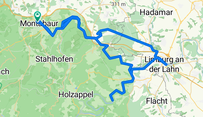
Montabaur-Limburg-Balduinstein
A cycling route starting in Montabaur, Rhineland-Palatinate, Germany.
Overview
About this route
- 1 h 27 min
- Duration
- 77.6 km
- Distance
- 550 m
- Ascent
- 542 m
- Descent
- 53.6 km/h
- Avg. speed
- ---
- Max. altitude

Route photos


Route quality
Waytypes & surfaces along the route
Waytypes
Track
28.4 km
(37 %)
Quiet road
12.5 km
(16 %)
Surfaces
Paved
51.4 km
(66 %)
Unpaved
16.2 km
(21 %)
Asphalt
42.6 km
(55 %)
Gravel
5.9 km
(8 %)
Continue with Bikemap
Use, edit, or download this cycling route
You would like to ride Montabaur-Limburg-Balduinstein or customize it for your own trip? Here is what you can do with this Bikemap route:
Free features
- Save this route as favorite or in collections
- Copy & plan your own version of this route
- Sync your route with Garmin or Wahoo
Premium features
Free trial for 3 days, or one-time payment. More about Bikemap Premium.
- Navigate this route on iOS & Android
- Export a GPX / KML file of this route
- Create your custom printout (try it for free)
- Download this route for offline navigation
Discover more Premium features.
Get Bikemap PremiumFrom our community
Other popular routes starting in Montabaur
 Impfroute
- Distance
- 32 km
- Ascent
- 515 m
- Descent
- 389 m
- Location
- Montabaur, Rhineland-Palatinate, Germany
 Einfache Fahrt in Vallendar
- Distance
- 24.5 km
- Ascent
- 522 m
- Descent
- 589 m
- Location
- Montabaur, Rhineland-Palatinate, Germany
 Montabaur-Wirges-Ruppach-Montabaur
- Distance
- 23.3 km
- Ascent
- 248 m
- Descent
- 247 m
- Location
- Montabaur, Rhineland-Palatinate, Germany
 Gelbachhöhen-Gelbachtal
- Distance
- 26.1 km
- Ascent
- 338 m
- Descent
- 337 m
- Location
- Montabaur, Rhineland-Palatinate, Germany
 Horrenden-Arzbach-Welschneudorf-Horressen
- Distance
- 18.3 km
- Ascent
- 483 m
- Descent
- 371 m
- Location
- Montabaur, Rhineland-Palatinate, Germany
 Kleine Ausfahrt
- Distance
- 26 km
- Ascent
- 253 m
- Descent
- 252 m
- Location
- Montabaur, Rhineland-Palatinate, Germany
 Montabaur - Ransbach - Vallendar - Koblenz
- Distance
- 40.1 km
- Ascent
- 489 m
- Descent
- 629 m
- Location
- Montabaur, Rhineland-Palatinate, Germany
 Gelbachhöhen-Gelbachtal
- Distance
- 26.1 km
- Ascent
- 328 m
- Descent
- 329 m
- Location
- Montabaur, Rhineland-Palatinate, Germany
Open it in the app