

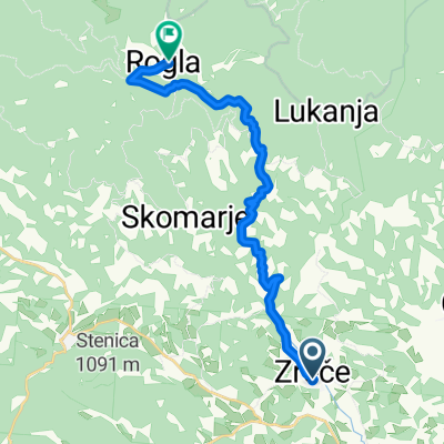
ROGLA, por Zrece
A cycling route starting in Zreče, Zreče Municipality, Slovenia.
Overview
About this route
Subida.
- -:--
- Duration
- 15.1 km
- Distance
- 1,063 m
- Ascent
- 0 m
- Descent
- ---
- Avg. speed
- ---
- Max. altitude

Route quality
Waytypes & surfaces along the route
Waytypes
Road
15.1 km
(100 %)
Surfaces
Paved
4.7 km
(31 %)
Asphalt
4.7 km
(31 %)
Undefined
10.4 km
(69 %)
Continue with Bikemap
Use, edit, or download this cycling route
You would like to ride ROGLA, por Zrece or customize it for your own trip? Here is what you can do with this Bikemap route:
Free features
- Save this route as favorite or in collections
- Copy & plan your own version of this route
- Sync your route with Garmin or Wahoo
Premium features
Free trial for 3 days, or one-time payment. More about Bikemap Premium.
- Navigate this route on iOS & Android
- Export a GPX / KML file of this route
- Create your custom printout (try it for free)
- Download this route for offline navigation
Discover more Premium features.
Get Bikemap PremiumFrom our community
Other popular routes starting in Zreče
 Radana vas - Golek
- Distance
- 15.1 km
- Ascent
- 386 m
- Descent
- 386 m
- Location
- Zreče, Zreče Municipality, Slovenia
 Krožna okrog in čez Boč
- Distance
- 66.4 km
- Ascent
- 805 m
- Descent
- 805 m
- Location
- Zreče, Zreče Municipality, Slovenia
 dalle Terme alla Rogla
- Distance
- 52.6 km
- Ascent
- 1,433 m
- Descent
- 1,433 m
- Location
- Zreče, Zreče Municipality, Slovenia
 Zreče-Sv.Vid-Zreče
- Distance
- 20.8 km
- Ascent
- 499 m
- Descent
- 496 m
- Location
- Zreče, Zreče Municipality, Slovenia
 Krožna po smeri Padeški vrh-Planina na Pohorju-Cezlak
- Distance
- 29.8 km
- Ascent
- 869 m
- Descent
- 867 m
- Location
- Zreče, Zreče Municipality, Slovenia
 Krožna čez Paški Kozjak
- Distance
- 61.8 km
- Ascent
- 1,050 m
- Descent
- 1,050 m
- Location
- Zreče, Zreče Municipality, Slovenia
 Zreče - Rogla
- Distance
- 16.7 km
- Ascent
- 1,078 m
- Descent
- 0 m
- Location
- Zreče, Zreče Municipality, Slovenia
 PT 1.dan: Bellevue - TK Pačnik (Resnik)
- Distance
- 44.7 km
- Ascent
- 914 m
- Descent
- 836 m
- Location
- Zreče, Zreče Municipality, Slovenia
Open it in the app