
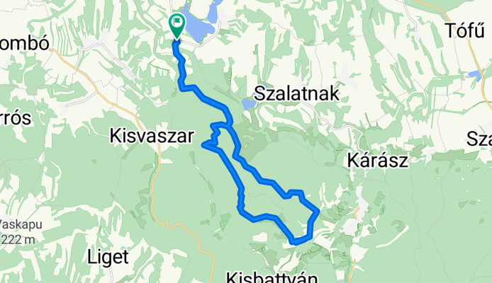
Nagyerdő hegy - leánykő
A cycling route starting in Mágocs, Baranya, Hungary.
Overview
About this route
Pleasant forest trail route on forestry roads... MTB, trekking, cross trekking.
- -:--
- Duration
- 24.2 km
- Distance
- 404 m
- Ascent
- 403 m
- Descent
- ---
- Avg. speed
- ---
- Max. altitude

Route quality
Waytypes & surfaces along the route
Waytypes
Track
15.5 km
(64 %)
Quiet road
8.5 km
(35 %)
Undefined
0.2 km
(1 %)
Surfaces
Paved
8.7 km
(36 %)
Unpaved
9.2 km
(38 %)
Asphalt
8.7 km
(36 %)
Ground
8 km
(33 %)
Route highlights
Points of interest along the route

Point of interest after 10 km
Kilátás a környékre

Point of interest after 10.4 km
Kilátás a környékre

Point of interest after 11.4 km
Kilátás a környékre!

Point of interest after 13.1 km
Leánykő! Gyalogosan közelíthető meg. Ajánlót a zárt túra ruházat.
Continue with Bikemap
Use, edit, or download this cycling route
You would like to ride Nagyerdő hegy - leánykő or customize it for your own trip? Here is what you can do with this Bikemap route:
Free features
- Save this route as favorite or in collections
- Copy & plan your own version of this route
- Sync your route with Garmin or Wahoo
Premium features
Free trial for 3 days, or one-time payment. More about Bikemap Premium.
- Navigate this route on iOS & Android
- Export a GPX / KML file of this route
- Create your custom printout (try it for free)
- Download this route for offline navigation
Discover more Premium features.
Get Bikemap PremiumFrom our community
Other popular routes starting in Mágocs
 Mágocs - Komló b) terv :)
- Distance
- 70.9 km
- Ascent
- 683 m
- Descent
- 676 m
- Location
- Mágocs, Baranya, Hungary
 Mágocs_Mecsek-Mágocs
- Distance
- 99.4 km
- Ascent
- 703 m
- Descent
- 709 m
- Location
- Mágocs, Baranya, Hungary
 Bikal ride 3.
- Distance
- 75.1 km
- Ascent
- 548 m
- Descent
- 550 m
- Location
- Mágocs, Baranya, Hungary
 2018tavasz-terv
- Distance
- 204.6 km
- Ascent
- 1,030 m
- Descent
- 1,046 m
- Location
- Mágocs, Baranya, Hungary
 Mágocs-Komló
- Distance
- 63.7 km
- Ascent
- 575 m
- Descent
- 568 m
- Location
- Mágocs, Baranya, Hungary
 Zöld + Turistaút (egykori)
- Distance
- 5.3 km
- Ascent
- 822 m
- Descent
- 822 m
- Location
- Mágocs, Baranya, Hungary
 Kisvaszar - Kisbattyán mecseki zöld karika
- Distance
- 21.7 km
- Ascent
- 386 m
- Descent
- 387 m
- Location
- Mágocs, Baranya, Hungary
 Árpád utca 97, Mágocs - Árpád utca 96, Mágocs
- Distance
- 46.6 km
- Ascent
- 407 m
- Descent
- 398 m
- Location
- Mágocs, Baranya, Hungary
Open it in the app