

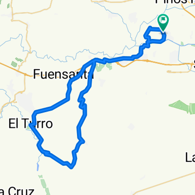
6-9-10 Llaneando por la Vega 2 (IBP: 15)
A cycling route starting in Fuente Vaqueros, Andalusia, Spain.
Overview
About this route
A more than easy route (IBP: 15) that we tackled today because our bikes were under repair, and additionally the situation got complicated with a flat tire that made us shorten our ride even more since we didn't have a spare. Everything is flat, with most paths pleasantly cool among poplar trees and typical valley crops, without any difficulty. It can serve for a refreshing ride late in the afternoon when time is short, and it might even be suitable for doing it with children.
- -:--
- Duration
- 21.2 km
- Distance
- 43 m
- Ascent
- 41 m
- Descent
- ---
- Avg. speed
- ---
- Max. altitude

Continue with Bikemap
Use, edit, or download this cycling route
You would like to ride 6-9-10 Llaneando por la Vega 2 (IBP: 15) or customize it for your own trip? Here is what you can do with this Bikemap route:
Free features
- Save this route as favorite or in collections
- Copy & plan your own version of this route
- Sync your route with Garmin or Wahoo
Premium features
Free trial for 3 days, or one-time payment. More about Bikemap Premium.
- Navigate this route on iOS & Android
- Export a GPX / KML file of this route
- Create your custom printout (try it for free)
- Download this route for offline navigation
Discover more Premium features.
Get Bikemap PremiumFrom our community
Other popular routes starting in Fuente Vaqueros
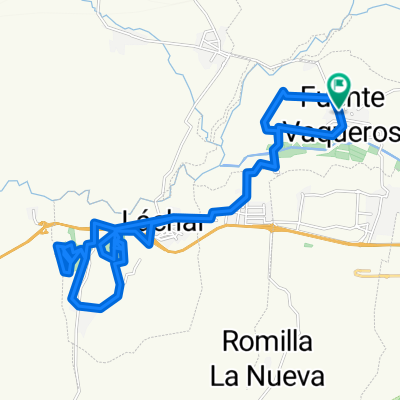
 25-8-10 F.Vaqueros-Cijuela-Láchar-Castillo de Tajarja-Cjo. Bujeda-El Turro (IBP: 50)
- Distance
- 55.6 km
- Ascent
- 472 m
- Descent
- 472 m
- Location
- Fuente Vaqueros, Andalusia, Spain
 22-9-10 Sierra Elvira: carriles, veredas, Torreón de Albolote y Ermita de los Tres Juanes (IBP: 67)
- Distance
- 35 km
- Ascent
- 500 m
- Descent
- 499 m
- Location
- Fuente Vaqueros, Andalusia, Spain
 22-8-10 F.Vaqueros-PinosPuente-Búcor-Tiena-Moclín-Tózar-Colomera-Berbes (IBP: 102)
- Distance
- 64.1 km
- Ascent
- 1,004 m
- Descent
- 1,004 m
- Location
- Fuente Vaqueros, Andalusia, Spain
 11-9-10 F.Vaqueros-El Jau-Parque Periurbano de Santa Fe (toboganes y vereda) (IBP: 48)
- Distance
- 37 km
- Ascent
- 405 m
- Descent
- 406 m
- Location
- Fuente Vaqueros, Andalusia, Spain
 12-9-10 F.Vaqueros-Cijuela-Romilla la Nueva-Canal de Cacín-Chimeneas-Aguas Calientes-El Jau (IBP:40)
- Distance
- 44.3 km
- Ascent
- 333 m
- Descent
- 331 m
- Location
- Fuente Vaqueros, Andalusia, Spain
 11-6-10 Ruta de los conejos (F.Vaqueros-Láchar-Daimuz-Brácana-La Loma) (IBP: 54)
- Distance
- 54.7 km
- Ascent
- 388 m
- Descent
- 388 m
- Location
- Fuente Vaqueros, Andalusia, Spain
 21-9-10 Pinares de Láchar ('Las Zorreras') y Peñuelas ('Los Pinos'), (IBP: 35)
- Distance
- 31.8 km
- Ascent
- 171 m
- Descent
- 171 m
- Location
- Fuente Vaqueros, Andalusia, Spain
 6-9-10 Llaneando por la Vega 2 (IBP: 15)
- Distance
- 21.2 km
- Ascent
- 43 m
- Descent
- 41 m
- Location
- Fuente Vaqueros, Andalusia, Spain
Open it in the app