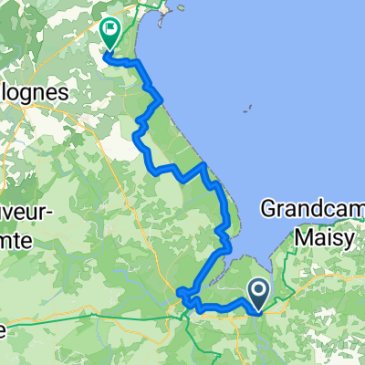
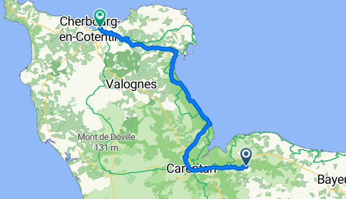
last day
A cycling route starting in Isigny-sur-Mer, Normandy, France.
Overview
About this route
- -:--
 - Duration
 - 86.5 km
 - Distance
 - 321 m
 - Ascent
 - 333 m
 - Descent
 - ---
 - Avg. speed
 - ---
 - Max. altitude
 
Route quality
Waytypes & surfaces along the route
Waytypes
Road
27.7 km
(32 %)
Quiet road
12.1 km
(14 %)
Surfaces
Paved
70.9 km
(82 %)
Unpaved
0.9 km
(1 %)
Asphalt
70.9 km
(82 %)
Ground
0.9 km
(1 %)
Undefined
14.7 km
(17 %)
Continue with Bikemap
Use, edit, or download this cycling route
You would like to ride last day or customize it for your own trip? Here is what you can do with this Bikemap route:
Free features
- Save this route as favorite or in collections
 - Copy & plan your own version of this route
 - Split it into stages to create a multi-day tour
 - Sync your route with Garmin or Wahoo
 
Premium features
Free trial for 3 days, or one-time payment. More about Bikemap Premium.
- Navigate this route on iOS & Android
 - Export a GPX / KML file of this route
 - Create your custom printout (try it for free)
 - Download this route for offline navigation
 
Discover more Premium features.
Get Bikemap PremiumFrom our community
Other popular routes starting in Isigny-sur-Mer
Cérisy-la-Forêt_70,6km_270hm- Distance
 - 70.6 km
 - Ascent
 - 226 m
 - Descent
 - 225 m
 - Location
 - Isigny-sur-Mer, Normandy, France
 
Route von Rupalley- Distance
 - 52.6 km
 - Ascent
 - 283 m
 - Descent
 - 350 m
 - Location
 - Isigny-sur-Mer, Normandy, France
 
Isigny - Port en Bessin- Distance
 - 47.1 km
 - Ascent
 - 309 m
 - Descent
 - 310 m
 - Location
 - Isigny-sur-Mer, Normandy, France
 
Isigny/mer Dieppe 12 jours- Distance
 - 319.9 km
 - Ascent
 - 683 m
 - Descent
 - 683 m
 - Location
 - Isigny-sur-Mer, Normandy, France
 
Isigny-sur-Mer - Quettehou- Distance
 - 57.1 km
 - Ascent
 - 156 m
 - Descent
 - 124 m
 - Location
 - Isigny-sur-Mer, Normandy, France
 
Géfosse-Fontenay - Pointe Hoc, 30km- Distance
 - 30.8 km
 - Ascent
 - 77 m
 - Descent
 - 77 m
 - Location
 - Isigny-sur-Mer, Normandy, France
 
Mon Tour de France - Etape 5- Distance
 - 98.4 km
 - Ascent
 - 516 m
 - Descent
 - 508 m
 - Location
 - Isigny-sur-Mer, Normandy, France
 
Route Rupalley nach Chemin des Sabions- Distance
 - 48.9 km
 - Ascent
 - 204 m
 - Descent
 - 221 m
 - Location
 - Isigny-sur-Mer, Normandy, France
 
Open it in the app


