

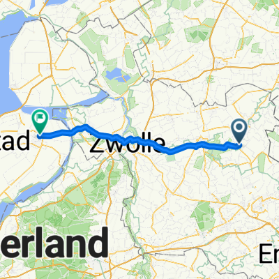
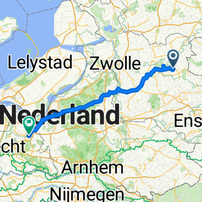
Fietsroute tussen Vroomshoop en Vriezenveen
A cycling route starting in Vroomshoop, Overijssel, The Netherlands.
Overview
About this route
The canal between Vroomshoop and Zwolle was opened in June 1855. This allowed Vroomshoop to have a bridge. When the drawbridge 'De kleine Puntbrug' needed replacement in 2007, because cars and freight traffic could not safely use the bridge, the municipality wanted to replace the bridge with a dam. In response, local residents protested, as they considered the tourist value of the bridge important too. People living in the Frisian Veen had to pay an annual rent of a bucket of butter at St. Martin. This rent could not be bought off.
- 1 h 47 min
- Duration
- 29.7 km
- Distance
- 32 m
- Ascent
- 30 m
- Descent
- 16.6 km/h
- Avg. speed
- ---
- Max. altitude

Route quality
Waytypes & surfaces along the route
Waytypes
Quiet road
20.2 km
(68 %)
Cycleway
6.5 km
(22 %)
Surfaces
Paved
17.5 km
(59 %)
Unpaved
3.9 km
(13 %)
Asphalt
17.2 km
(58 %)
Loose gravel
3.9 km
(13 %)
Continue with Bikemap
Use, edit, or download this cycling route
You would like to ride Fietsroute tussen Vroomshoop en Vriezenveen or customize it for your own trip? Here is what you can do with this Bikemap route:
Free features
- Save this route as favorite or in collections
- Copy & plan your own version of this route
- Sync your route with Garmin or Wahoo
Premium features
Free trial for 3 days, or one-time payment. More about Bikemap Premium.
- Navigate this route on iOS & Android
- Export a GPX / KML file of this route
- Create your custom printout (try it for free)
- Download this route for offline navigation
Discover more Premium features.
Get Bikemap PremiumFrom our community
Other popular routes starting in Vroomshoop
 82_2022_Tussen_Vroomshoop_en_Vriezenveen_V21
- Distance
- 34.8 km
- Ascent
- 67 m
- Descent
- 66 m
- Location
- Vroomshoop, Overijssel, The Netherlands
 Rondje Marc
- Distance
- 38.1 km
- Ascent
- 71 m
- Descent
- 74 m
- Location
- Vroomshoop, Overijssel, The Netherlands
 Trainingsrondje Lemelerberg
- Distance
- 38.6 km
- Ascent
- 83 m
- Descent
- 85 m
- Location
- Vroomshoop, Overijssel, The Netherlands
 Vroomshoop - Dronten
- Distance
- 66.1 km
- Ascent
- 93 m
- Descent
- 106 m
- Location
- Vroomshoop, Overijssel, The Netherlands
 Fietsroute tussen Vroomshoop en Vriezenveen
- Distance
- 29.7 km
- Ascent
- 32 m
- Descent
- 30 m
- Location
- Vroomshoop, Overijssel, The Netherlands
 Beerzeveld to Amersfoort
- Distance
- 112.9 km
- Ascent
- 226 m
- Descent
- 277 m
- Location
- Vroomshoop, Overijssel, The Netherlands
 Rondje Almelo
- Distance
- 17.3 km
- Ascent
- 23 m
- Descent
- 20 m
- Location
- Vroomshoop, Overijssel, The Netherlands
 marienberg naar lemelerberg
- Distance
- 37.9 km
- Ascent
- 87 m
- Descent
- 84 m
- Location
- Vroomshoop, Overijssel, The Netherlands
Open it in the app