

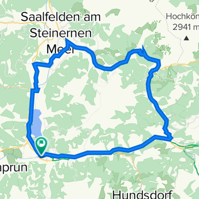
"Queralp" von Fusch an der Glocknerstrasse nach Bad Gastein
A cycling route starting in Bruck an der Großglocknerstraße, Salzburg, Austria.
Overview
About this route
Anspruchsvolle 3 Täler Überschreitung:<br />-Grossglockner -Hochalpenstrasse
-Seidlwinkltal (wunderschön)
-Gasteinertal
Route ist sehr anspruchsvoll 2 längere Tragepassagen (1h und 45min).
In Summe ca. 2700hm und ca. 80km
aber Wunderschön und Geheimtipp!
Hinweis: Empfohlen fürs Wochenende, da dann Steinbruch bei Rauris (Stanzscharte ) nicht in Betrieb ist. -mögliche Sprengungen etc.
- -:--
- Duration
- 78.9 km
- Distance
- 2,909 m
- Ascent
- 2,623 m
- Descent
- ---
- Avg. speed
- ---
- Max. altitude
Route highlights
Points of interest along the route
Point of interest after 24 km
Abzweigung Mittertörl. Unmittelbar nach Tunnel den "Römersteig" folgend in das Seidlwinkltal ca. 600hm abfahren (weitgehend Tragepassagen) ca. 1h bis zu Litztlhofalm
Point of interest after 61.8 km
Stanzscharte 2100m; Von da Rad bis zu den Gadauner-Hochmialmen tragen (ca. 45min)
Continue with Bikemap
Use, edit, or download this cycling route
You would like to ride "Queralp" von Fusch an der Glocknerstrasse nach Bad Gastein or customize it for your own trip? Here is what you can do with this Bikemap route:
Free features
- Save this route as favorite or in collections
- Copy & plan your own version of this route
- Sync your route with Garmin or Wahoo
Premium features
Free trial for 3 days, or one-time payment. More about Bikemap Premium.
- Navigate this route on iOS & Android
- Export a GPX / KML file of this route
- Create your custom printout (try it for free)
- Download this route for offline navigation
Discover more Premium features.
Get Bikemap PremiumFrom our community
Other popular routes starting in Bruck an der Großglocknerstraße
 Glocknerkönig
- Distance
- 27.3 km
- Ascent
- 1,699 m
- Descent
- 222 m
- Location
- Bruck an der Großglocknerstraße, Salzburg, Austria
 Zell am See / Kaprun
- Distance
- 66.4 km
- Ascent
- 746 m
- Descent
- 747 m
- Location
- Bruck an der Großglocknerstraße, Salzburg, Austria
 Bruck a d G - Edelweißspitze-Großglockner-Heiligenblut-Aichhorn
- Distance
- 72.4 km
- Ascent
- 2,675 m
- Descent
- 2,342 m
- Location
- Bruck an der Großglocknerstraße, Salzburg, Austria
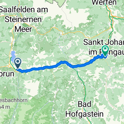 Von Bruck an der Großglocknerstraße bis Sankt Johann im Pongau
- Distance
- 37.6 km
- Ascent
- 944 m
- Descent
- 979 m
- Location
- Bruck an der Großglocknerstraße, Salzburg, Austria
 "Queralp" von Fusch an der Glocknerstrasse nach Bad Gastein
- Distance
- 78.9 km
- Ascent
- 2,909 m
- Descent
- 2,623 m
- Location
- Bruck an der Großglocknerstraße, Salzburg, Austria
 Über den Höchsten den wir haben
- Distance
- 48.5 km
- Ascent
- 2,373 m
- Descent
- 1,642 m
- Location
- Bruck an der Großglocknerstraße, Salzburg, Austria
 Route in Bruck an der Großglocknerstraße
- Distance
- 49.6 km
- Ascent
- 584 m
- Descent
- 584 m
- Location
- Bruck an der Großglocknerstraße, Salzburg, Austria
 Fusch Grossglockner
- Distance
- 19.1 km
- Ascent
- 1,605 m
- Descent
- 26 m
- Location
- Bruck an der Großglocknerstraße, Salzburg, Austria
Open it in the app