

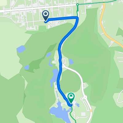
De Boulevard maritime Nord 55, Fort-Mahon-Plage à Camping Le Ridin, Le Crotoy
A cycling route starting in Fort-Mahon-Plage, Hauts-de-France, France.
Overview
About this route
- 1 h 17 min
- Duration
- 18.2 km
- Distance
- 52 m
- Ascent
- 56 m
- Descent
- 14.1 km/h
- Avg. speed
- ---
- Max. altitude

Route photos


Route quality
Waytypes & surfaces along the route
Waytypes
Quiet road
10.5 km
(58 %)
Road
4.7 km
(26 %)
Surfaces
Paved
5.3 km
(29 %)
Asphalt
4.5 km
(25 %)
Concrete
0.7 km
(4 %)
Undefined
12.9 km
(71 %)
Continue with Bikemap
Use, edit, or download this cycling route
You would like to ride De Boulevard maritime Nord 55, Fort-Mahon-Plage à Camping Le Ridin, Le Crotoy or customize it for your own trip? Here is what you can do with this Bikemap route:
Free features
- Save this route as favorite or in collections
- Copy & plan your own version of this route
- Sync your route with Garmin or Wahoo
Premium features
Free trial for 3 days, or one-time payment. More about Bikemap Premium.
- Navigate this route on iOS & Android
- Export a GPX / KML file of this route
- Create your custom printout (try it for free)
- Download this route for offline navigation
Discover more Premium features.
Get Bikemap PremiumFrom our community
Other popular routes starting in Fort-Mahon-Plage
 Avenue des Pins 11, Quend nach Avenue des Pins 11, Quend
- Distance
- 45.5 km
- Ascent
- 70 m
- Descent
- 72 m
- Location
- Fort-Mahon-Plage, Hauts-de-France, France
 89 Rue Lavoisier, Fort-Mahon-Plage à 89 Rue Lavoisier, Fort-Mahon-Plage
- Distance
- 24.4 km
- Ascent
- 197 m
- Descent
- 189 m
- Location
- Fort-Mahon-Plage, Hauts-de-France, France
 439 Rue du Général de Gaulle, Fort-Mahon-Plage à Eurovélo Quatre-Véloroute de l'Europe Centrale, Fort-Mahon-Plage
- Distance
- 1.4 km
- Ascent
- 6 m
- Descent
- 7 m
- Location
- Fort-Mahon-Plage, Hauts-de-France, France
 De 2–6 Avenue Foch, Quend à 1–3 Rue de la Mairie, Wail
- Distance
- 78 km
- Ascent
- 376 m
- Descent
- 352 m
- Location
- Fort-Mahon-Plage, Hauts-de-France, France
 Avenue des Pins 11, Quend nach Avenue des Pins 11, Quend
- Distance
- 67.8 km
- Ascent
- 123 m
- Descent
- 123 m
- Location
- Fort-Mahon-Plage, Hauts-de-France, France
 4 Allée de Bretagne, Fort-Mahon-Plage à Eurovélo Quatre-Véloroute de l'Europe Centrale, Fort-Mahon-Plage
- Distance
- 1.4 km
- Ascent
- 0 m
- Descent
- 0 m
- Location
- Fort-Mahon-Plage, Hauts-de-France, France
 Fort-Mahon à Deauville
- Distance
- 308.2 km
- Ascent
- 757 m
- Descent
- 764 m
- Location
- Fort-Mahon-Plage, Hauts-de-France, France
 15 Allée de Bretagne, Fort-Mahon-Plage à 1 Plaine du Royon, Fort-Mahon-Plage
- Distance
- 1.5 km
- Ascent
- 0 m
- Descent
- 4 m
- Location
- Fort-Mahon-Plage, Hauts-de-France, France
Open it in the app