

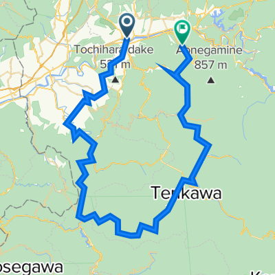
天川村〜すずかけの道ヒルクライム
A cycling route starting in Yoshino-chō, Nara, Japan.
Overview
About this route
Even though it was so tough, if I were to plot that climb in a graph, it would look something like this. The green flag marks the location of the transmission tower. The climb distance is 3.5 km, with an elevation gain of 270 m. Still a long way to go, Kuragari Pass. Wait for me! Kuragari Pass.
- -:--
- Duration
- 3.5 km
- Distance
- 317 m
- Ascent
- 93 m
- Descent
- ---
- Avg. speed
- ---
- Max. altitude

Route quality
Waytypes & surfaces along the route
Waytypes
Quiet road
1.5 km
(43 %)
Undefined
2 km
(57 %)
Continue with Bikemap
Use, edit, or download this cycling route
You would like to ride 天川村〜すずかけの道ヒルクライム or customize it for your own trip? Here is what you can do with this Bikemap route:
Free features
- Save this route as favorite or in collections
- Copy & plan your own version of this route
- Sync your route with Garmin or Wahoo
Premium features
Free trial for 3 days, or one-time payment. More about Bikemap Premium.
- Navigate this route on iOS & Android
- Export a GPX / KML file of this route
- Create your custom printout (try it for free)
- Download this route for offline navigation
Discover more Premium features.
Get Bikemap PremiumFrom our community
Other popular routes starting in Yoshino-chō
 天川村〜すずかけの道ヒルクライム
- Distance
- 3.5 km
- Ascent
- 317 m
- Descent
- 93 m
- Location
- Yoshino-chō, Nara, Japan
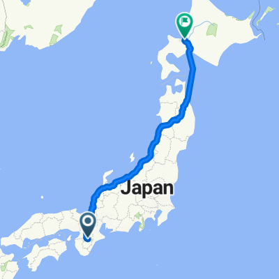 nara to sapporo
- Distance
- 1,433.5 km
- Ascent
- 851 m
- Descent
- 1,346 m
- Location
- Yoshino-chō, Nara, Japan
 洞川温泉ライド
- Distance
- 88.1 km
- Ascent
- 4,005 m
- Descent
- 3,936 m
- Location
- Yoshino-chō, Nara, Japan
 津風呂湖カヌー体験コース
- Distance
- 13.3 km
- Ascent
- 398 m
- Descent
- 399 m
- Location
- Yoshino-chō, Nara, Japan
 東吉野村サイクリング
- Distance
- 24.4 km
- Ascent
- 898 m
- Descent
- 900 m
- Location
- Yoshino-chō, Nara, Japan
 Mont Yoshino - kudoyama
- Distance
- 40.9 km
- Ascent
- 354 m
- Descent
- 375 m
- Location
- Yoshino-chō, Nara, Japan
 Omura to Toba
- Distance
- 114.2 km
- Ascent
- 785 m
- Descent
- 1,073 m
- Location
- Yoshino-chō, Nara, Japan
 number 18 ferry tokushima
- Distance
- 133.8 km
- Ascent
- 37 m
- Descent
- 181 m
- Location
- Yoshino-chō, Nara, Japan
Open it in the app