

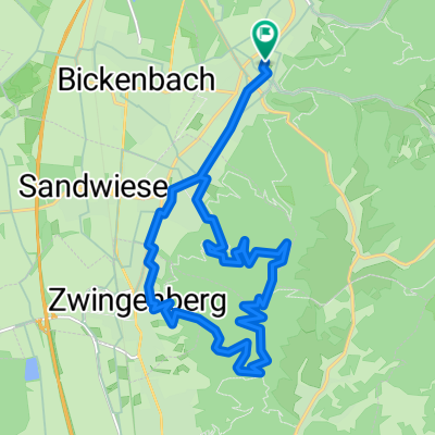
MTT2020 - Tag 1 - 1
A cycling route starting in Seeheim-Jugenheim, Hesse, Germany.
Overview
About this route
- -:--
- Duration
- 19.3 km
- Distance
- 157 m
- Ascent
- 376 m
- Descent
- ---
- Avg. speed
- ---
- Max. altitude

Route quality
Waytypes & surfaces along the route
Waytypes
Track
5.4 km
(28 %)
Quiet road
4.6 km
(24 %)
Surfaces
Paved
15.8 km
(82 %)
Unpaved
2.5 km
(13 %)
Asphalt
15.6 km
(81 %)
Gravel
1.4 km
(7 %)
Route highlights
Points of interest along the route
Point of interest after 0 km
Kuralpe

Point of interest after 19.3 km
1. Treffpunkt
Continue with Bikemap
Use, edit, or download this cycling route
You would like to ride MTT2020 - Tag 1 - 1 or customize it for your own trip? Here is what you can do with this Bikemap route:
Free features
- Save this route as favorite or in collections
- Copy & plan your own version of this route
- Sync your route with Garmin or Wahoo
Premium features
Free trial for 3 days, or one-time payment. More about Bikemap Premium.
- Navigate this route on iOS & Android
- Export a GPX / KML file of this route
- Create your custom printout (try it for free)
- Download this route for offline navigation
Discover more Premium features.
Get Bikemap PremiumFrom our community
Other popular routes starting in Seeheim-Jugenheim
 Friedrich-Ebert-Straße, Seeheim-Jugenheim nach Friedrich-Ebert-Straße, Seeheim-Jugenheim
- Distance
- 13.9 km
- Ascent
- 60 m
- Descent
- 60 m
- Location
- Seeheim-Jugenheim, Hesse, Germany
 Friedrich-Ebert-Straße, Seeheim-Jugenheim nach Friedrich-Ebert-Straße, Seeheim-Jugenheim
- Distance
- 40.4 km
- Ascent
- 484 m
- Descent
- 483 m
- Location
- Seeheim-Jugenheim, Hesse, Germany
 MTT2020 - Tag 1 - 1
- Distance
- 19.3 km
- Ascent
- 157 m
- Descent
- 376 m
- Location
- Seeheim-Jugenheim, Hesse, Germany
 Friedrich-Ebert-Straße, Seeheim-Jugenheim nach Friedrich-Ebert-Straße, Seeheim-Jugenheim
- Distance
- 39.6 km
- Ascent
- 357 m
- Descent
- 354 m
- Location
- Seeheim-Jugenheim, Hesse, Germany
 Lindenfelsrunde
- Distance
- 65.1 km
- Ascent
- 988 m
- Descent
- 977 m
- Location
- Seeheim-Jugenheim, Hesse, Germany
 Route in Seeheim-Jugenheim
- Distance
- 19.4 km
- Ascent
- 771 m
- Descent
- 773 m
- Location
- Seeheim-Jugenheim, Hesse, Germany
 Friedrich-Ebert-Straße, Seeheim-Jugenheim nach Friedrich-Ebert-Straße, Seeheim-Jugenheim
- Distance
- 25.4 km
- Ascent
- 313 m
- Descent
- 312 m
- Location
- Seeheim-Jugenheim, Hesse, Germany
 Groß-Biberau
- Distance
- 50.8 km
- Ascent
- 826 m
- Descent
- 825 m
- Location
- Seeheim-Jugenheim, Hesse, Germany
Open it in the app