

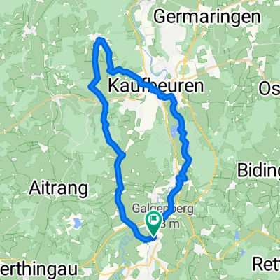
MTB-Runde Tempel - Kuhstallweiher
A cycling route starting in Marktoberdorf, Bavaria, Germany.
Overview
About this route
Abseits großer Straßen, viele Feld- und Waldwege. Immer wieder Wurzelwege. Teilweise technisch anspruchsvoll.
- -:--
- Duration
- 14.7 km
- Distance
- 244 m
- Ascent
- 242 m
- Descent
- ---
- Avg. speed
- ---
- Max. altitude
Route quality
Waytypes & surfaces along the route
Waytypes
Track
8.8 km
(60 %)
Quiet road
3.5 km
(24 %)
Surfaces
Paved
7 km
(48 %)
Unpaved
4.5 km
(31 %)
Asphalt
5.1 km
(35 %)
Gravel
3.5 km
(24 %)
Route highlights
Points of interest along the route
Point of interest after 0.3 km
Starke Steigung in der Kurfürstenstraße
Point of interest after 5.8 km
Gefährliche Querung über die B16
Point of interest after 6.7 km
Guter Wurzeltrail und Ausblick übers Gennachtal zum Auerberg
Point of interest after 9.2 km
Gefährliche Querung der B16 am Hochwieswald
Point of interest after 10.1 km
Vielzahl von Wurzeltrails im Wald
Point of interest after 10.5 km
Badegelegenheit am Kuhstallweiher
Point of interest after 12.5 km
Bike-Parcours und weitere Trails
Continue with Bikemap
Use, edit, or download this cycling route
You would like to ride MTB-Runde Tempel - Kuhstallweiher or customize it for your own trip? Here is what you can do with this Bikemap route:
Free features
- Save this route as favorite or in collections
- Copy & plan your own version of this route
- Sync your route with Garmin or Wahoo
Premium features
Free trial for 3 days, or one-time payment. More about Bikemap Premium.
- Navigate this route on iOS & Android
- Export a GPX / KML file of this route
- Create your custom printout (try it for free)
- Download this route for offline navigation
Discover more Premium features.
Get Bikemap PremiumFrom our community
Other popular routes starting in Marktoberdorf
 Dampflokrunde
- Distance
- 78.6 km
- Ascent
- 358 m
- Descent
- 361 m
- Location
- Marktoberdorf, Bavaria, Germany
 MOD - 48 km - Wittwe-Bolte-Weiher - Kessa -MOD
- Distance
- 48.3 km
- Ascent
- 277 m
- Descent
- 277 m
- Location
- Marktoberdorf, Bavaria, Germany
 MOD-Rettenbach
- Distance
- 31.4 km
- Ascent
- 341 m
- Descent
- 340 m
- Location
- Marktoberdorf, Bavaria, Germany
 MOD - Irsee
- Distance
- 36.6 km
- Ascent
- 229 m
- Descent
- 232 m
- Location
- Marktoberdorf, Bavaria, Germany
 MOD-Runde
- Distance
- 47.8 km
- Ascent
- 293 m
- Descent
- 290 m
- Location
- Marktoberdorf, Bavaria, Germany
 Mod - 54,8 - Mod
- Distance
- 54.8 km
- Ascent
- 275 m
- Descent
- 273 m
- Location
- Marktoberdorf, Bavaria, Germany
 Sulzschneider Forst
- Distance
- 30.1 km
- Ascent
- 190 m
- Descent
- 190 m
- Location
- Marktoberdorf, Bavaria, Germany
 Transalp 09
- Distance
- 532.1 km
- Ascent
- 8,015 m
- Descent
- 8,678 m
- Location
- Marktoberdorf, Bavaria, Germany
Open it in the app