

Burke-Gilman Trail
A cycling route starting in Shoreline, Washington, United States.
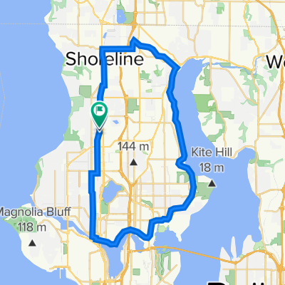
Overview
About this route
The famous Burke-Gilman Trail! This paved trail began as part of a nationwide rails-to-trails movement that, beginning in the 1960s, converted abandoned or unused rail corridors into public trails. The B-G takes you through a very wide variety of urban and suburban habitats – from the old industrial area of Ballard to the parks of Bothell. Perfect if you just want to ride and not worry about car traffic, complicated directions, or big hills.
- -:--
- Duration
- 33.9 km
- Distance
- 82 m
- Ascent
- 72 m
- Descent
- ---
- Avg. speed
- ---
- Max. altitude

Route quality
Waytypes & surfaces along the route
Waytypes
Cycleway
28.4 km
(84 %)
Road
2.4 km
(7 %)
Surfaces
Paved
31.8 km
(94 %)
Asphalt
20.3 km
(60 %)
Paved (undefined)
10.8 km
(32 %)
Continue with Bikemap
Use, edit, or download this cycling route
You would like to ride Burke-Gilman Trail or customize it for your own trip? Here is what you can do with this Bikemap route:
Free features
- Save this route as favorite or in collections
- Copy & plan your own version of this route
- Sync your route with Garmin or Wahoo
Premium features
Free trial for 3 days, or one-time payment. More about Bikemap Premium.
- Navigate this route on iOS & Android
- Export a GPX / KML file of this route
- Create your custom printout (try it for free)
- Download this route for offline navigation
Discover more Premium features.
Get Bikemap PremiumFrom our community
Other popular routes starting in Shoreline
 First lag
- Distance
- 849.9 km
- Ascent
- 2,803 m
- Descent
- 1,690 m
- Location
- Shoreline, Washington, United States
 936 N 76th St, Seattle to 1555 NE Pacific St, Seattle
- Distance
- 5.7 km
- Ascent
- 18 m
- Descent
- 70 m
- Location
- Shoreline, Washington, United States
 North Seattle to Lake Seattle
- Distance
- 78.7 km
- Ascent
- 370 m
- Descent
- 431 m
- Location
- Shoreline, Washington, United States
 Fremont Ave N, Shoreline to 31st Ave NW, Seattle
- Distance
- 12.6 km
- Ascent
- 80 m
- Descent
- 131 m
- Location
- Shoreline, Washington, United States
 Shoreline to Greenlake, Via Interurban Trail
- Distance
- 24.9 km
- Ascent
- 141 m
- Descent
- 141 m
- Location
- Shoreline, Washington, United States
 60613-1
- Distance
- 31.4 km
- Ascent
- 220 m
- Descent
- 149 m
- Location
- Shoreline, Washington, United States
 Something Something bike rides
- Distance
- 38.4 km
- Ascent
- 343 m
- Descent
- 345 m
- Location
- Shoreline, Washington, United States
 Seattle Perimeter Loop
- Distance
- 123 km
- Ascent
- 628 m
- Descent
- 628 m
- Location
- Shoreline, Washington, United States
Open it in the app